You are here: Home > Network List > TA - USArray Transportable Network (new EarthScope stations) Stations List
> Station 334A Lometa, TX, USA > Earthquake Result Viewer
334A Lometa, TX, USA - Earthquake Result Viewer
*The percent match for this event was below the threshold and hence no stack was calculated.
| Earthquake location: |
Near East Coast Of Honshu, Japan |
| Earthquake latitude/longitude: |
37.5/141.7 |
| Earthquake time(UTC): |
2011/04/28 (118) 09:27:47 GMT |
| Earthquake Depth: |
38 km |
| Earthquake Magnitude: |
5.8 MB, 5.1 MS, 5.6 MW, 5.5 MW |
| Earthquake Catalog/Contributor: |
WHDF/NEIC |
|
| Network: |
TA USArray Transportable Network (new EarthScope stations) |
| Station: |
334A Lometa, TX, USA |
| Lat/Lon: |
31.33 N/98.24 W |
| Elevation: |
389 m |
|
| Distance: |
91.6 deg |
| Az: |
47.778 deg |
| Baz: |
316.473 deg |
| Ray Param: |
$rayparam |
*The percent match for this event was below the threshold and hence was not used in the summary stack. |
|
| Radial Match: |
62.47369 % |
| Radial Bump: |
400 |
| Transverse Match: |
44.735218 % |
| Transverse Bump: |
380 |
| SOD ConfigId: |
356183 |
| Insert Time: |
2011-10-01 11:55:19.449 +0000 |
| GWidth: |
2.5 |
| Max Bumps: |
400 |
| Tol: |
0.001 |
|
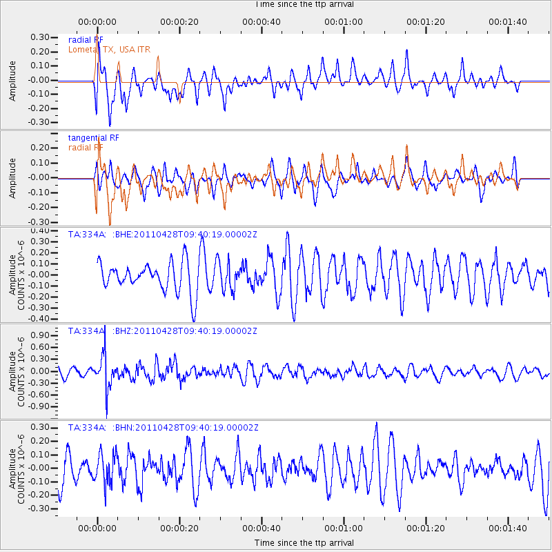
Signal To Noise
| Channel | StoN | STA | LTA |
| TA:334A: :BHZ:20110428T09:40:19.00002Z | 4.5069265 | 4.0879974E-7 | 9.070477E-8 |
| TA:334A: :BHN:20110428T09:40:19.00002Z | 1.0446782 | 1.11983475E-7 | 1.07194225E-7 |
| TA:334A: :BHE:20110428T09:40:19.00002Z | 0.9497424 | 1.2419616E-7 | 1.3076826E-7 |
| Arrivals |
| Ps | |
| PpPs | |
| PsPs/PpSs | |


