You are here: Home > Network List > TA - USArray Transportable Network (new EarthScope stations) Stations List
> Station B32A Ashes, Strandquist, MN, USA > Earthquake Result Viewer
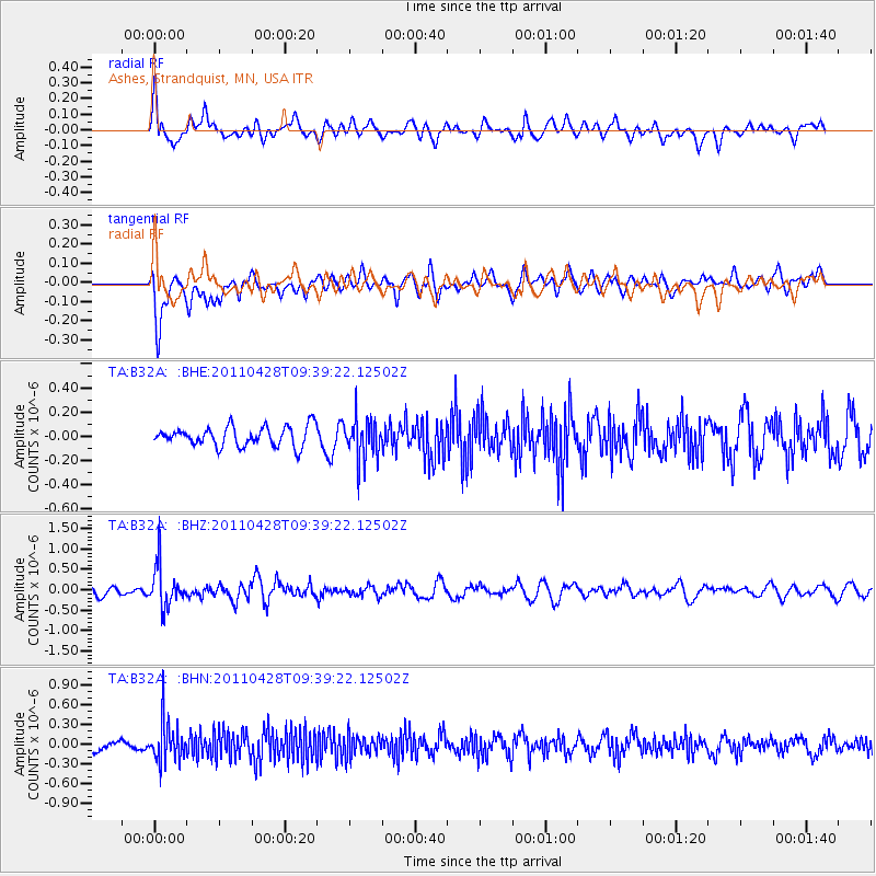
B32A Ashes, Strandquist, MN, USA - Earthquake Result Viewer
*The percent match for this event was below the threshold and hence no stack was calculated.
| Earthquake location: |
Near East Coast Of Honshu, Japan |
| Earthquake latitude/longitude: |
37.5/141.7 |
| Earthquake time(UTC): |
2011/04/28 (118) 09:27:47 GMT |
| Earthquake Depth: |
38 km |
| Earthquake Magnitude: |
5.8 MB, 5.1 MS, 5.6 MW, 5.5 MW |
| Earthquake Catalog/Contributor: |
WHDF/NEIC |
|
| Network: |
TA USArray Transportable Network (new EarthScope stations) |
| Station: |
B32A Ashes, Strandquist, MN, USA |
| Lat/Lon: |
48.40 N/96.54 W |
| Elevation: |
335 m |
|
| Distance: |
80.1 deg |
| Az: |
35.095 deg |
| Baz: |
316.648 deg |
| Ray Param: |
$rayparam |
*The percent match for this event was below the threshold and hence was not used in the summary stack. |
|
| Radial Match: |
57.21483 % |
| Radial Bump: |
400 |
| Transverse Match: |
64.580536 % |
| Transverse Bump: |
400 |
| SOD ConfigId: |
356183 |
| Insert Time: |
2011-10-01 12:35:39.546 +0000 |
| GWidth: |
2.5 |
| Max Bumps: |
400 |
| Tol: |
0.001 |
|
Signal To Noise
| Channel | StoN | STA | LTA |
| TA:B32A: :BHZ:20110428T09:39:22.12502Z | 4.769599 | 4.9459504E-7 | 1.036974E-7 |
| TA:B32A: :BHN:20110428T09:39:22.12502Z | 4.9354672 | 3.0177938E-7 | 6.1145045E-8 |
| TA:B32A: :BHE:20110428T09:39:22.12502Z | 2.0503669 | 1.6571889E-7 | 8.0824016E-8 |
| Arrivals |
| Ps | |
| PpPs | |
| PsPs/PpSs | |


