You are here: Home > Network List > TA - USArray Transportable Network (new EarthScope stations) Stations List
> Station T38A Diamond, MO, USA > Earthquake Result Viewer
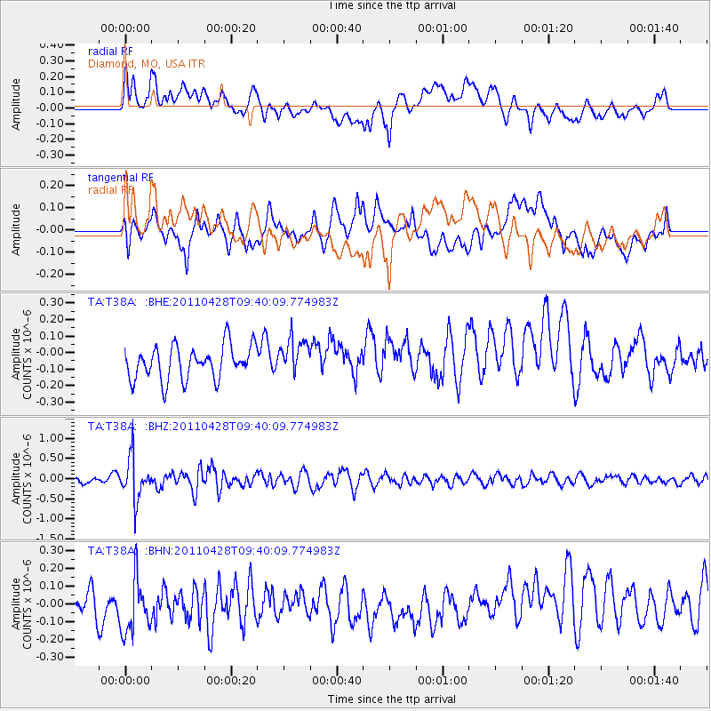
T38A Diamond, MO, USA - Earthquake Result Viewer
*The percent match for this event was below the threshold and hence no stack was calculated.
| Earthquake location: |
Near East Coast Of Honshu, Japan |
| Earthquake latitude/longitude: |
37.5/141.7 |
| Earthquake time(UTC): |
2011/04/28 (118) 09:27:47 GMT |
| Earthquake Depth: |
38 km |
| Earthquake Magnitude: |
5.8 MB, 5.1 MS, 5.6 MW, 5.5 MW |
| Earthquake Catalog/Contributor: |
WHDF/NEIC |
|
| Network: |
TA USArray Transportable Network (new EarthScope stations) |
| Station: |
T38A Diamond, MO, USA |
| Lat/Lon: |
37.04 N/94.29 W |
| Elevation: |
349 m |
|
| Distance: |
89.6 deg |
| Az: |
41.528 deg |
| Baz: |
318.75 deg |
| Ray Param: |
$rayparam |
*The percent match for this event was below the threshold and hence was not used in the summary stack. |
|
| Radial Match: |
45.328724 % |
| Radial Bump: |
400 |
| Transverse Match: |
54.454323 % |
| Transverse Bump: |
400 |
| SOD ConfigId: |
356183 |
| Insert Time: |
2011-10-01 13:09:17.178 +0000 |
| GWidth: |
2.5 |
| Max Bumps: |
400 |
| Tol: |
0.001 |
|
Signal To Noise
| Channel | StoN | STA | LTA |
| TA:T38A: :BHZ:20110428T09:40:09.774983Z | 6.021134 | 5.247073E-7 | 8.714427E-8 |
| TA:T38A: :BHN:20110428T09:40:09.774983Z | 1.6934955 | 1.9185694E-7 | 1.1329049E-7 |
| TA:T38A: :BHE:20110428T09:40:09.774983Z | 1.0873549 | 1.10457854E-7 | 1.01584E-7 |
| Arrivals |
| Ps | |
| PpPs | |
| PsPs/PpSs | |


