You are here: Home > Network List > TA - USArray Transportable Network (new EarthScope stations) Stations List
> Station Z42A Norrel Spur, Hamburg, AR, USA > Earthquake Result Viewer
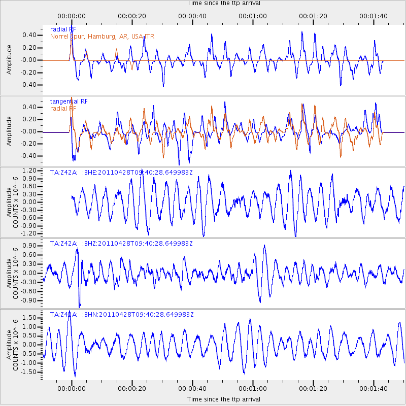
Z42A Norrel Spur, Hamburg, AR, USA - Earthquake Result Viewer
*The percent match for this event was below the threshold and hence no stack was calculated.
| Earthquake location: |
Near East Coast Of Honshu, Japan |
| Earthquake latitude/longitude: |
37.5/141.7 |
| Earthquake time(UTC): |
2011/04/28 (118) 09:27:47 GMT |
| Earthquake Depth: |
38 km |
| Earthquake Magnitude: |
5.8 MB, 5.1 MS, 5.6 MW, 5.5 MW |
| Earthquake Catalog/Contributor: |
WHDF/NEIC |
|
| Network: |
TA USArray Transportable Network (new EarthScope stations) |
| Station: |
Z42A Norrel Spur, Hamburg, AR, USA |
| Lat/Lon: |
33.27 N/91.95 W |
| Elevation: |
39 m |
|
| Distance: |
93.7 deg |
| Az: |
42.51 deg |
| Baz: |
320.067 deg |
| Ray Param: |
$rayparam |
*The percent match for this event was below the threshold and hence was not used in the summary stack. |
|
| Radial Match: |
50.28248 % |
| Radial Bump: |
314 |
| Transverse Match: |
61.27812 % |
| Transverse Bump: |
400 |
| SOD ConfigId: |
356183 |
| Insert Time: |
2011-10-01 13:13:46.588 +0000 |
| GWidth: |
2.5 |
| Max Bumps: |
400 |
| Tol: |
0.001 |
|
Signal To Noise
| Channel | StoN | STA | LTA |
| TA:Z42A: :BHZ:20110428T09:40:28.649983Z | 2.152782 | 5.26414E-7 | 2.445273E-7 |
| TA:Z42A: :BHN:20110428T09:40:28.649983Z | 2.3116956 | 9.777591E-7 | 4.2296185E-7 |
| TA:Z42A: :BHE:20110428T09:40:28.649983Z | 1.1185439 | 5.49487E-7 | 4.9125214E-7 |
| Arrivals |
| Ps | |
| PpPs | |
| PsPs/PpSs | |


