You are here: Home > Network List > KN - Kyrgyz Seismic Telemetry Network Stations List
> Station TKM2 KN.TKM2 > Earthquake Result Viewer
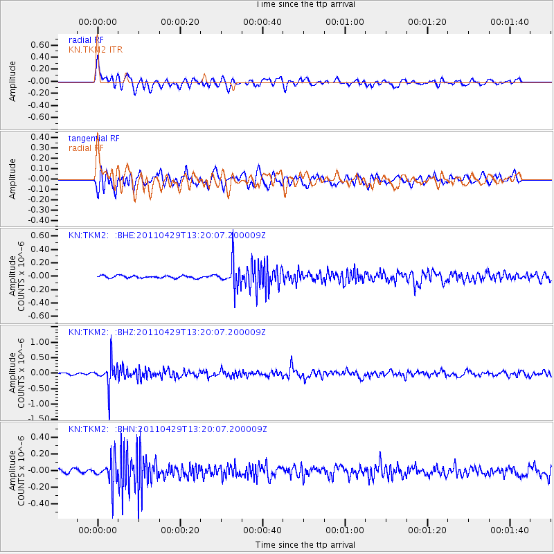
TKM2 KN.TKM2 - Earthquake Result Viewer
*The percent match for this event was below the threshold and hence no stack was calculated.
| Earthquake location: |
Taiwan Region |
| Earthquake latitude/longitude: |
21.1/122.0 |
| Earthquake time(UTC): |
2011/04/29 (119) 13:12:46 GMT |
| Earthquake Depth: |
181 km |
| Earthquake Magnitude: |
5.5 MB, 5.4 MW, 5.3 MW |
| Earthquake Catalog/Contributor: |
WHDF/NEIC |
|
| Network: |
KN Kyrgyz Seismic Telemetry Network |
| Station: |
TKM2 KN.TKM2 |
| Lat/Lon: |
42.92 N/75.60 E |
| Elevation: |
2020 m |
|
| Distance: |
44.3 deg |
| Az: |
310.343 deg |
| Baz: |
104.386 deg |
| Ray Param: |
$rayparam |
*The percent match for this event was below the threshold and hence was not used in the summary stack. |
|
| Radial Match: |
63.865448 % |
| Radial Bump: |
400 |
| Transverse Match: |
65.17169 % |
| Transverse Bump: |
400 |
| SOD ConfigId: |
356183 |
| Insert Time: |
2011-10-01 14:12:56.698 +0000 |
| GWidth: |
2.5 |
| Max Bumps: |
400 |
| Tol: |
0.001 |
|
Signal To Noise
| Channel | StoN | STA | LTA |
| KN:TKM2: :BHZ:20110429T13:20:07.200009Z | 14.99546 | 4.2404193E-7 | 2.8278022E-8 |
| KN:TKM2: :BHN:20110429T13:20:07.200009Z | 6.0383034 | 1.5546162E-7 | 2.574591E-8 |
| KN:TKM2: :BHE:20110429T13:20:07.200009Z | 10.710272 | 1.9056539E-7 | 1.7792768E-8 |
| Arrivals |
| Ps | |
| PpPs | |
| PsPs/PpSs | |


