You are here: Home > Network List > UW - Pacific Northwest Regional Seismic Network Stations List
> Station PASS Maple Falls, WA, USA > Earthquake Result Viewer
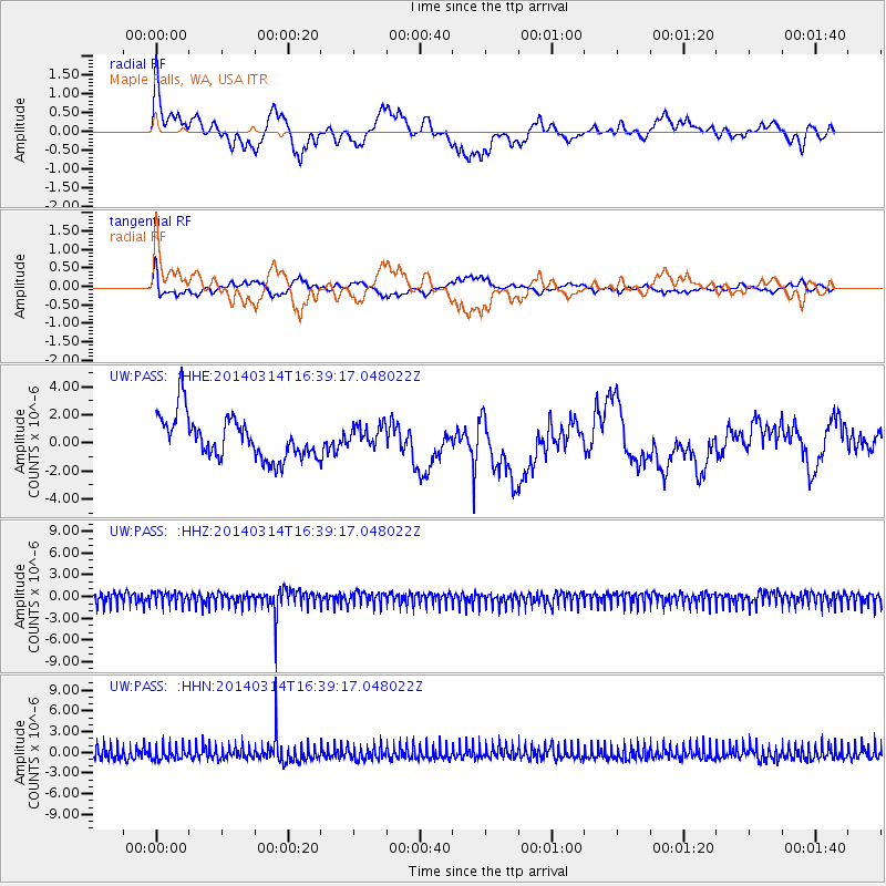
PASS Maple Falls, WA, USA - Earthquake Result Viewer
*The percent match for this event was below the threshold and hence no stack was calculated.
| Earthquake location: |
Volcano Islands, Japan Region |
| Earthquake latitude/longitude: |
25.1/141.7 |
| Earthquake time(UTC): |
2014/03/14 (073) 16:28:58 GMT |
| Earthquake Depth: |
521 km |
| Earthquake Magnitude: |
4.9 mb |
| Earthquake Catalog/Contributor: |
ISC/ISC |
|
| Network: |
UW Pacific Northwest Regional Seismic Network |
| Station: |
PASS Maple Falls, WA, USA |
| Lat/Lon: |
49.00 N/122.09 W |
| Elevation: |
174 m |
|
| Distance: |
75.4 deg |
| Az: |
42.58 deg |
| Baz: |
291.353 deg |
| Ray Param: |
$rayparam |
*The percent match for this event was below the threshold and hence was not used in the summary stack. |
|
| Radial Match: |
63.48675 % |
| Radial Bump: |
359 |
| Transverse Match: |
63.378117 % |
| Transverse Bump: |
376 |
| SOD ConfigId: |
3390531 |
| Insert Time: |
2019-04-10 15:57:44.957 +0000 |
| GWidth: |
2.5 |
| Max Bumps: |
400 |
| Tol: |
0.001 |
|
Signal To Noise
| Channel | StoN | STA | LTA |
| UW:PASS: :HHZ:20140314T16:39:17.048022Z | 1.0267408 | 8.596404E-7 | 8.372516E-7 |
| UW:PASS: :HHN:20140314T16:39:17.048022Z | 1.016373 | 9.660295E-7 | 9.504675E-7 |
| UW:PASS: :HHE:20140314T16:39:17.048022Z | 0.5295324 | 7.948729E-7 | 1.5010847E-6 |
| Arrivals |
| Ps | |
| PpPs | |
| PsPs/PpSs | |


