You are here: Home > Network List > IW - Intermountain West Stations List
> Station PHWY Pilot Hill, Wyoming, USA > Earthquake Result Viewer
PHWY Pilot Hill, Wyoming, USA - Earthquake Result Viewer
| Earthquake location: |
South Of Panama |
| Earthquake latitude/longitude: |
6.9/-82.3 |
| Earthquake time(UTC): |
2011/04/30 (120) 08:19:16 GMT |
| Earthquake Depth: |
8.0 km |
| Earthquake Magnitude: |
5.8 MB, 5.7 MS, 6.2 MW, 6.0 MW |
| Earthquake Catalog/Contributor: |
WHDF/NEIC |
|
| Network: |
IW Intermountain West |
| Station: |
PHWY Pilot Hill, Wyoming, USA |
| Lat/Lon: |
41.30 N/105.46 W |
| Elevation: |
2645 m |
|
| Distance: |
40.0 deg |
| Az: |
332.597 deg |
| Baz: |
142.659 deg |
| Ray Param: |
0.074649684 |
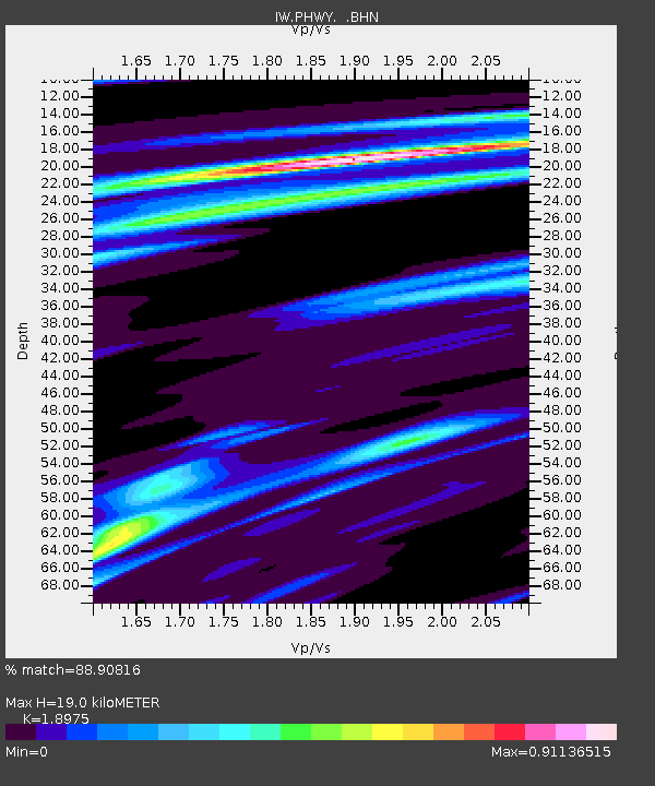
| Estimated Moho Depth: |
19.0 km |
| Estimated Crust Vp/Vs: |
1.90 |
| Assumed Crust Vp: |
6.306 km/s |
| Estimated Crust Vs: |
3.323 km/s |
| Estimated Crust Poisson's Ratio: |
0.31 |
|
| Radial Match: |
88.90816 % |
| Radial Bump: |
265 |
| Transverse Match: |
54.097378 % |
| Transverse Bump: |
400 |
| SOD ConfigId: |
356183 |
| Insert Time: |
2011-10-06 04:47:35.245 +0000 |
| GWidth: |
2.5 |
| Max Bumps: |
400 |
| Tol: |
0.001 |
|

Signal To Noise
| Channel | StoN | STA | LTA |
| IW:PHWY: :BHZ:20110430T08:26:20.415001Z | 4.2724485 | 2.473933E-7 | 5.790434E-8 |
| IW:PHWY: :BHN:20110430T08:26:20.415001Z | 2.3860407 | 1.16085445E-7 | 4.8651916E-8 |
| IW:PHWY: :BHE:20110430T08:26:20.415001Z | 3.126997 | 1.2571881E-7 | 4.0204327E-8 |
| Arrivals |
| Ps | 2.9 SECOND |
| PpPs | 8.2 SECOND |
| PsPs/PpSs | 11 SECOND |


