You are here: Home > Network List > TA - USArray Transportable Network (new EarthScope stations) Stations List
> Station I25A Rochford, SD, USA > Earthquake Result Viewer
I25A Rochford, SD, USA - Earthquake Result Viewer

| Earthquake location: |
South Of Panama |
| Earthquake latitude/longitude: |
6.9/-82.3 |
| Earthquake time(UTC): |
2011/04/30 (120) 08:19:16 GMT |
| Earthquake Depth: |
8.0 km |
| Earthquake Magnitude: |
5.8 MB, 5.7 MS, 6.2 MW, 6.0 MW |
| Earthquake Catalog/Contributor: |
WHDF/NEIC |
|
| Network: |
TA USArray Transportable Network (new EarthScope stations) |
| Station: |
I25A Rochford, SD, USA |
| Lat/Lon: |
44.02 N/103.73 W |
| Elevation: |
1856 m |
|
| Distance: |
41.5 deg |
| Az: |
336.591 deg |
| Baz: |
146.851 deg |
| Ray Param: |
0.073762 |
| Estimated Moho Depth: |
28.25 km |
| Estimated Crust Vp/Vs: |
1.63 |
| Assumed Crust Vp: |
6.242 km/s |
| Estimated Crust Vs: |
3.818 km/s |
| Estimated Crust Poisson's Ratio: |
0.20 |
|
| Radial Match: |
92.14891 % |
| Radial Bump: |
321 |
| Transverse Match: |
67.356834 % |
| Transverse Bump: |
400 |
| SOD ConfigId: |
356183 |
| Insert Time: |
2011-10-06 04:57:33.944 +0000 |
| GWidth: |
2.5 |
| Max Bumps: |
400 |
| Tol: |
0.001 |
|
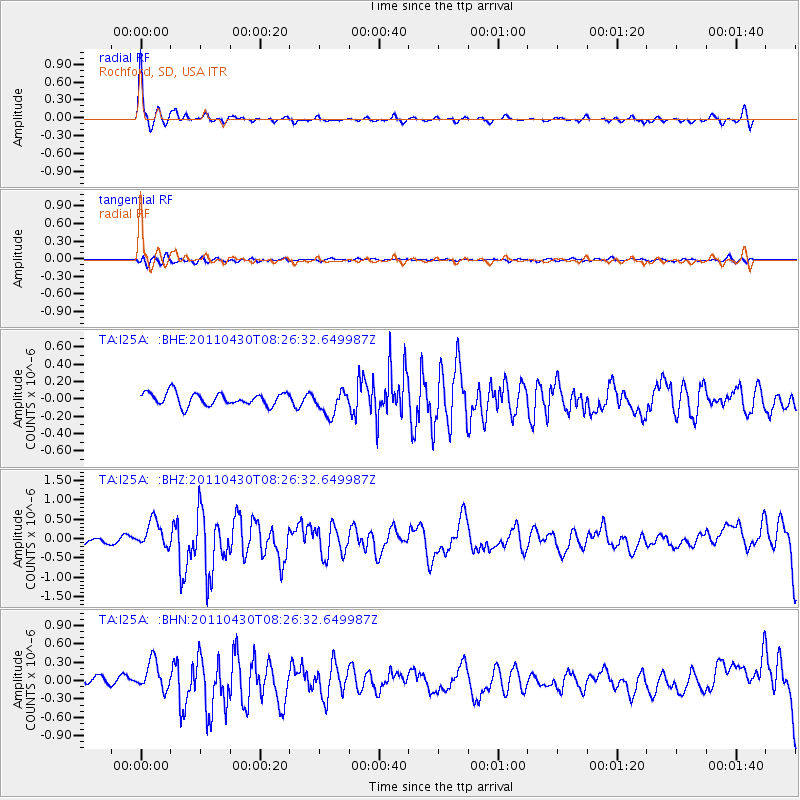
Signal To Noise
| Channel | StoN | STA | LTA |
| TA:I25A: :BHZ:20110430T08:26:32.649987Z | 4.2741103 | 3.5150984E-7 | 8.224164E-8 |
| TA:I25A: :BHN:20110430T08:26:32.649987Z | 3.9297054 | 2.4169066E-7 | 6.1503506E-8 |
| TA:I25A: :BHE:20110430T08:26:32.649987Z | 1.8777722 | 1.3863323E-7 | 7.382856E-8 |
| Arrivals |
| Ps | 3.1 SECOND |
| PpPs | 11 SECOND |
| PsPs/PpSs | 14 SECOND |


