You are here: Home > Network List > TA - USArray Transportable Network (new EarthScope stations) Stations List
> Station R35A Emporia Municipal Airport, Emporia, KS, USA > Earthquake Result Viewer
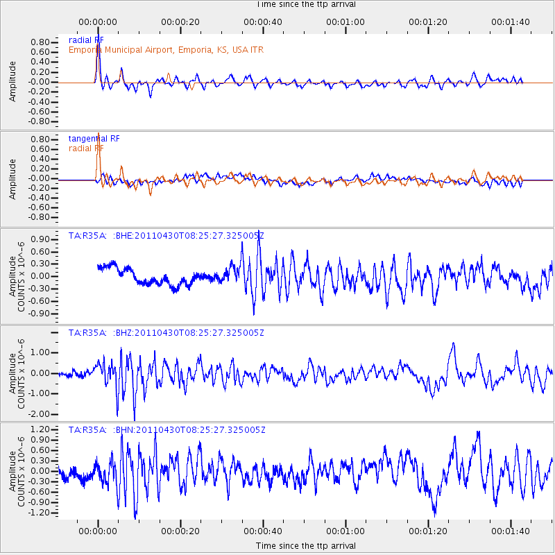
R35A Emporia Municipal Airport, Emporia, KS, USA - Earthquake Result Viewer
*The percent match for this event was below the threshold and hence no stack was calculated.
| Earthquake location: |
South Of Panama |
| Earthquake latitude/longitude: |
6.9/-82.3 |
| Earthquake time(UTC): |
2011/04/30 (120) 08:19:16 GMT |
| Earthquake Depth: |
8.0 km |
| Earthquake Magnitude: |
5.8 MB, 5.7 MS, 6.2 MW, 6.0 MW |
| Earthquake Catalog/Contributor: |
WHDF/NEIC |
|
| Network: |
TA USArray Transportable Network (new EarthScope stations) |
| Station: |
R35A Emporia Municipal Airport, Emporia, KS, USA |
| Lat/Lon: |
38.32 N/96.20 W |
| Elevation: |
365 m |
|
| Distance: |
33.8 deg |
| Az: |
340.169 deg |
| Baz: |
154.643 deg |
| Ray Param: |
$rayparam |
*The percent match for this event was below the threshold and hence was not used in the summary stack. |
|
| Radial Match: |
79.72332 % |
| Radial Bump: |
400 |
| Transverse Match: |
60.42347 % |
| Transverse Bump: |
400 |
| SOD ConfigId: |
356183 |
| Insert Time: |
2011-10-06 05:23:46.076 +0000 |
| GWidth: |
2.5 |
| Max Bumps: |
400 |
| Tol: |
0.001 |
|
Signal To Noise
| Channel | StoN | STA | LTA |
| TA:R35A: :BHZ:20110430T08:25:27.325005Z | 4.293365 | 6.21315E-7 | 1.4471516E-7 |
| TA:R35A: :BHN:20110430T08:25:27.325005Z | 2.0550802 | 3.1968247E-7 | 1.5555716E-7 |
| TA:R35A: :BHE:20110430T08:25:27.325005Z | 1.2081007 | 2.3015022E-7 | 1.9050583E-7 |
| Arrivals |
| Ps | |
| PpPs | |
| PsPs/PpSs | |


