You are here: Home > Network List > UW - Pacific Northwest Regional Seismic Network Stations List
> Station UMAT Pilot Rock, OR, USA > Earthquake Result Viewer
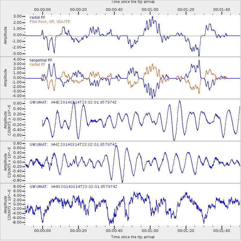
UMAT Pilot Rock, OR, USA - Earthquake Result Viewer
*The percent match for this event was below the threshold and hence no stack was calculated.
| Earthquake location: |
Tonga Islands Region |
| Earthquake latitude/longitude: |
-23.4/-175.3 |
| Earthquake time(UTC): |
2014/03/14 (073) 22:49:56 GMT |
| Earthquake Depth: |
14 km |
| Earthquake Magnitude: |
5.1 MW |
| Earthquake Catalog/Contributor: |
ISC/ISC |
|
| Network: |
UW Pacific Northwest Regional Seismic Network |
| Station: |
UMAT Pilot Rock, OR, USA |
| Lat/Lon: |
45.29 N/118.96 W |
| Elevation: |
1318 m |
|
| Distance: |
85.4 deg |
| Az: |
36.098 deg |
| Baz: |
230.08 deg |
| Ray Param: |
$rayparam |
*The percent match for this event was below the threshold and hence was not used in the summary stack. |
|
| Radial Match: |
36.23665 % |
| Radial Bump: |
400 |
| Transverse Match: |
36.710598 % |
| Transverse Bump: |
400 |
| SOD ConfigId: |
3390531 |
| Insert Time: |
2019-04-10 16:05:41.295 +0000 |
| GWidth: |
2.5 |
| Max Bumps: |
400 |
| Tol: |
0.001 |
|
Signal To Noise
| Channel | StoN | STA | LTA |
| UW:UMAT: :HHZ:20140314T23:02:01.957974Z | 0.5263467 | 1.4449239E-7 | 2.745194E-7 |
| UW:UMAT: :HHN:20140314T23:02:01.957974Z | 2.2998161 | 4.608561E-6 | 2.0038824E-6 |
| UW:UMAT: :HHE:20140314T23:02:01.957974Z | 0.29640308 | 1.0171716E-7 | 3.4317176E-7 |
| Arrivals |
| Ps | |
| PpPs | |
| PsPs/PpSs | |


