You are here: Home > Network List > TA - USArray Transportable Network (new EarthScope stations) Stations List
> Station U37A Salina, OK, USA > Earthquake Result Viewer
U37A Salina, OK, USA - Earthquake Result Viewer
| Earthquake location: |
South Of Panama |
| Earthquake latitude/longitude: |
6.9/-82.3 |
| Earthquake time(UTC): |
2011/04/30 (120) 08:19:16 GMT |
| Earthquake Depth: |
8.0 km |
| Earthquake Magnitude: |
5.8 MB, 5.7 MS, 6.2 MW, 6.0 MW |
| Earthquake Catalog/Contributor: |
WHDF/NEIC |
|
| Network: |
TA USArray Transportable Network (new EarthScope stations) |
| Station: |
U37A Salina, OK, USA |
| Lat/Lon: |
36.41 N/95.12 W |
| Elevation: |
248 m |
|
| Distance: |
31.7 deg |
| Az: |
340.116 deg |
| Baz: |
155.252 deg |
| Ray Param: |
0.078988306 |
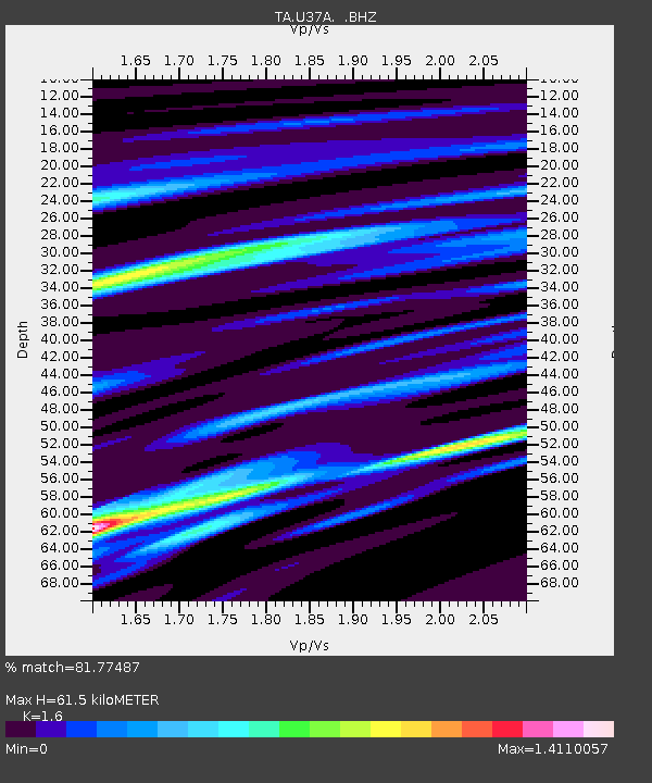
| Estimated Moho Depth: |
61.5 km |
| Estimated Crust Vp/Vs: |
1.60 |
| Assumed Crust Vp: |
6.53 km/s |
| Estimated Crust Vs: |
4.082 km/s |
| Estimated Crust Poisson's Ratio: |
0.18 |
|
| Radial Match: |
81.77487 % |
| Radial Bump: |
400 |
| Transverse Match: |
46.66804 % |
| Transverse Bump: |
400 |
| SOD ConfigId: |
356183 |
| Insert Time: |
2011-10-06 05:27:55.655 +0000 |
| GWidth: |
2.5 |
| Max Bumps: |
400 |
| Tol: |
0.001 |
|
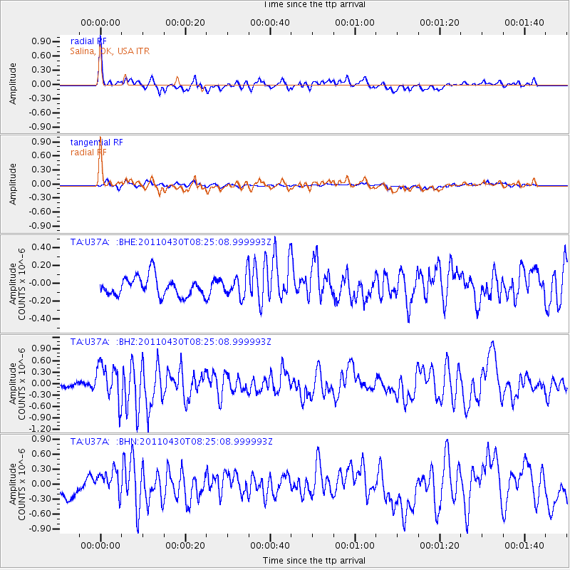
Signal To Noise
| Channel | StoN | STA | LTA |
| TA:U37A: :BHZ:20110430T08:25:08.999993Z | 6.96914 | 4.979054E-7 | 7.1444305E-8 |
| TA:U37A: :BHN:20110430T08:25:08.999993Z | 1.5171106 | 2.5208192E-7 | 1.6615923E-7 |
| TA:U37A: :BHE:20110430T08:25:08.999993Z | 1.1858997 | 1.2649727E-7 | 1.0666777E-7 |
| Arrivals |
| Ps | 6.2 SECOND |
| PpPs | 22 SECOND |
| PsPs/PpSs | 29 SECOND |


