You are here: Home > Network List > TA - USArray Transportable Network (new EarthScope stations) Stations List
> Station N33A J Bar K, Exeter, NE, USA > Earthquake Result Viewer
N33A J Bar K, Exeter, NE, USA - Earthquake Result Viewer

| Earthquake location: |
South Of Panama |
| Earthquake latitude/longitude: |
6.9/-82.3 |
| Earthquake time(UTC): |
2011/04/30 (120) 08:19:16 GMT |
| Earthquake Depth: |
8.0 km |
| Earthquake Magnitude: |
5.8 MB, 5.7 MS, 6.2 MW, 6.0 MW |
| Earthquake Catalog/Contributor: |
WHDF/NEIC |
|
| Network: |
TA USArray Transportable Network (new EarthScope stations) |
| Station: |
N33A J Bar K, Exeter, NE, USA |
| Lat/Lon: |
40.74 N/97.45 W |
| Elevation: |
475 m |
|
| Distance: |
36.3 deg |
| Az: |
340.466 deg |
| Baz: |
154.092 deg |
| Ray Param: |
0.076734416 |
| Estimated Moho Depth: |
20.25 km |
| Estimated Crust Vp/Vs: |
1.65 |
| Assumed Crust Vp: |
6.498 km/s |
| Estimated Crust Vs: |
3.938 km/s |
| Estimated Crust Poisson's Ratio: |
0.21 |
|
| Radial Match: |
91.70418 % |
| Radial Bump: |
353 |
| Transverse Match: |
74.12395 % |
| Transverse Bump: |
400 |
| SOD ConfigId: |
356183 |
| Insert Time: |
2011-10-06 05:28:11.082 +0000 |
| GWidth: |
2.5 |
| Max Bumps: |
400 |
| Tol: |
0.001 |
|
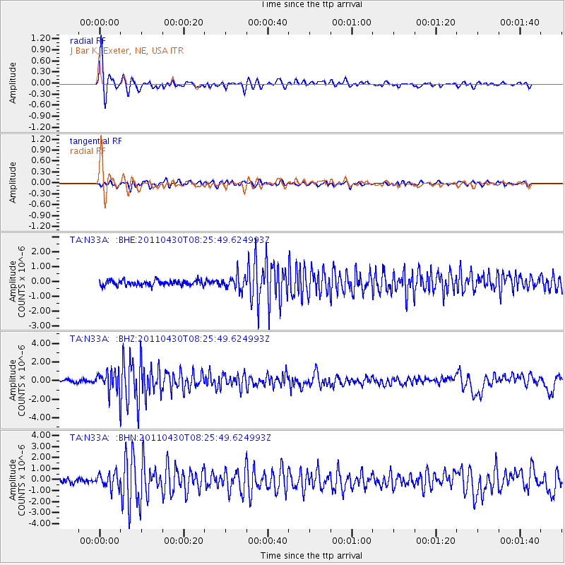
Signal To Noise
| Channel | StoN | STA | LTA |
| TA:N33A: :BHZ:20110430T08:25:49.624993Z | 7.695785 | 1.1440941E-6 | 1.4866504E-7 |
| TA:N33A: :BHN:20110430T08:25:49.624993Z | 3.0432875 | 6.728836E-7 | 2.2110417E-7 |
| TA:N33A: :BHE:20110430T08:25:49.624993Z | 2.611894 | 4.6397415E-7 | 1.7763897E-7 |
| Arrivals |
| Ps | 2.2 SECOND |
| PpPs | 7.6 SECOND |
| PsPs/PpSs | 9.8 SECOND |


