You are here: Home > Network List > TA - USArray Transportable Network (new EarthScope stations) Stations List
> Station G36A St. Michael, MN, USA > Earthquake Result Viewer
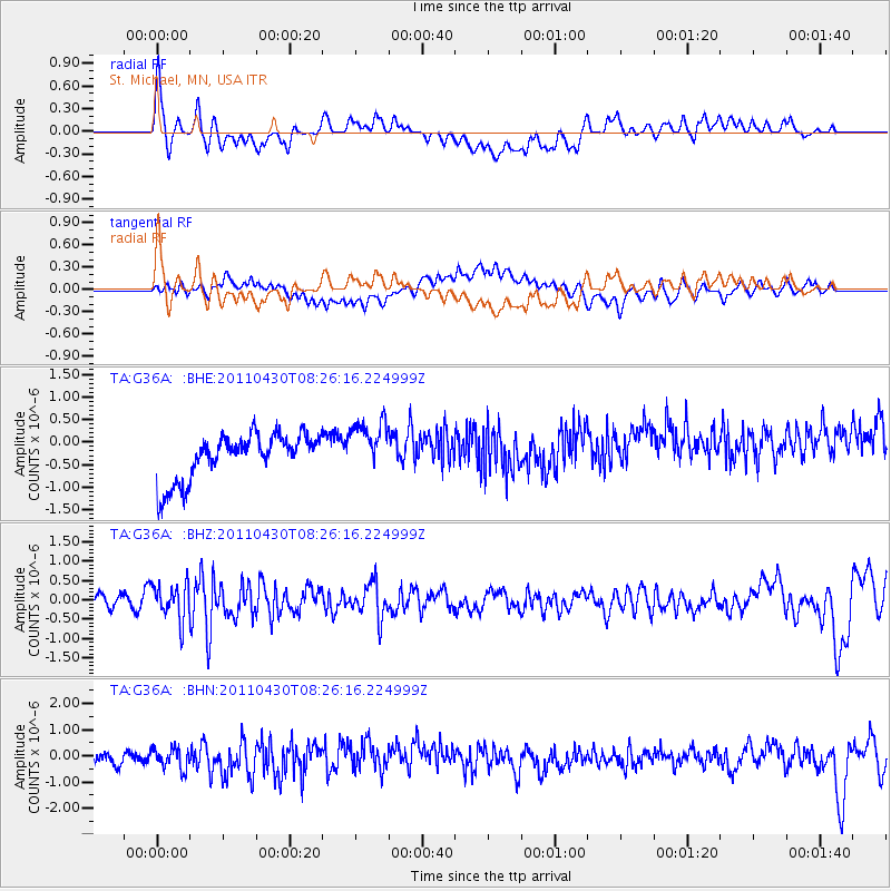
G36A St. Michael, MN, USA - Earthquake Result Viewer
*The percent match for this event was below the threshold and hence no stack was calculated.
| Earthquake location: |
South Of Panama |
| Earthquake latitude/longitude: |
6.9/-82.3 |
| Earthquake time(UTC): |
2011/04/30 (120) 08:19:16 GMT |
| Earthquake Depth: |
8.0 km |
| Earthquake Magnitude: |
5.8 MB, 5.7 MS, 6.2 MW, 6.0 MW |
| Earthquake Catalog/Contributor: |
WHDF/NEIC |
|
| Network: |
TA USArray Transportable Network (new EarthScope stations) |
| Station: |
G36A St. Michael, MN, USA |
| Lat/Lon: |
45.23 N/93.75 W |
| Elevation: |
293 m |
|
| Distance: |
39.5 deg |
| Az: |
347.297 deg |
| Baz: |
162.001 deg |
| Ray Param: |
$rayparam |
*The percent match for this event was below the threshold and hence was not used in the summary stack. |
|
| Radial Match: |
63.294064 % |
| Radial Bump: |
400 |
| Transverse Match: |
48.323586 % |
| Transverse Bump: |
400 |
| SOD ConfigId: |
356183 |
| Insert Time: |
2011-10-06 05:40:34.444 +0000 |
| GWidth: |
2.5 |
| Max Bumps: |
400 |
| Tol: |
0.001 |
|
Signal To Noise
| Channel | StoN | STA | LTA |
| TA:G36A: :BHZ:20110430T08:26:16.224999Z | 4.2842803 | 4.6204212E-7 | 1.0784592E-7 |
| TA:G36A: :BHN:20110430T08:26:16.224999Z | 1.0877962 | 4.3454142E-7 | 3.994695E-7 |
| TA:G36A: :BHE:20110430T08:26:16.224999Z | 1.1675848 | 5.9114575E-7 | 5.062979E-7 |
| Arrivals |
| Ps | |
| PpPs | |
| PsPs/PpSs | |


