You are here: Home > Network List > TA - USArray Transportable Network (new EarthScope stations) Stations List
> Station B34A Aery, Baudette, MN, USA > Earthquake Result Viewer
B34A Aery, Baudette, MN, USA - Earthquake Result Viewer
| Earthquake location: |
South Of Panama |
| Earthquake latitude/longitude: |
6.9/-82.3 |
| Earthquake time(UTC): |
2011/04/30 (120) 08:19:16 GMT |
| Earthquake Depth: |
8.0 km |
| Earthquake Magnitude: |
5.8 MB, 5.7 MS, 6.2 MW, 6.0 MW |
| Earthquake Catalog/Contributor: |
WHDF/NEIC |
|
| Network: |
TA USArray Transportable Network (new EarthScope stations) |
| Station: |
B34A Aery, Baudette, MN, USA |
| Lat/Lon: |
48.49 N/94.65 W |
| Elevation: |
354 m |
|
| Distance: |
42.8 deg |
| Az: |
347.94 deg |
| Baz: |
161.831 deg |
| Ray Param: |
0.07297058 |
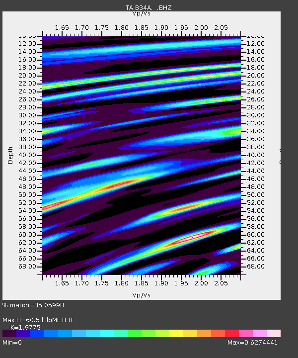
| Estimated Moho Depth: |
60.5 km |
| Estimated Crust Vp/Vs: |
1.98 |
| Assumed Crust Vp: |
6.419 km/s |
| Estimated Crust Vs: |
3.246 km/s |
| Estimated Crust Poisson's Ratio: |
0.33 |
|
| Radial Match: |
85.05998 % |
| Radial Bump: |
400 |
| Transverse Match: |
53.013382 % |
| Transverse Bump: |
400 |
| SOD ConfigId: |
356183 |
| Insert Time: |
2011-10-06 05:40:34.987 +0000 |
| GWidth: |
2.5 |
| Max Bumps: |
400 |
| Tol: |
0.001 |
|

Signal To Noise
| Channel | StoN | STA | LTA |
| TA:B34A: :BHZ:20110430T08:26:43.200005Z | 11.809084 | 8.6521743E-7 | 7.326711E-8 |
| TA:B34A: :BHN:20110430T08:26:43.200005Z | 7.673836 | 7.583681E-7 | 9.882516E-8 |
| TA:B34A: :BHE:20110430T08:26:43.200005Z | 3.14163 | 3.4610434E-7 | 1.1016713E-7 |
| Arrivals |
| Ps | 9.8 SECOND |
| PpPs | 26 SECOND |
| PsPs/PpSs | 36 SECOND |


