You are here: Home > Network List > TA - USArray Transportable Network (new EarthScope stations) Stations List
> Station P38A Dawn, MO, USA > Earthquake Result Viewer
P38A Dawn, MO, USA - Earthquake Result Viewer
| Earthquake location: |
South Of Panama |
| Earthquake latitude/longitude: |
6.9/-82.3 |
| Earthquake time(UTC): |
2011/04/30 (120) 08:19:16 GMT |
| Earthquake Depth: |
8.0 km |
| Earthquake Magnitude: |
5.8 MB, 5.7 MS, 6.2 MW, 6.0 MW |
| Earthquake Catalog/Contributor: |
WHDF/NEIC |
|
| Network: |
TA USArray Transportable Network (new EarthScope stations) |
| Station: |
P38A Dawn, MO, USA |
| Lat/Lon: |
39.62 N/93.53 W |
| Elevation: |
248 m |
|
| Distance: |
34.2 deg |
| Az: |
344.502 deg |
| Baz: |
159.908 deg |
| Ray Param: |
0.07788361 |
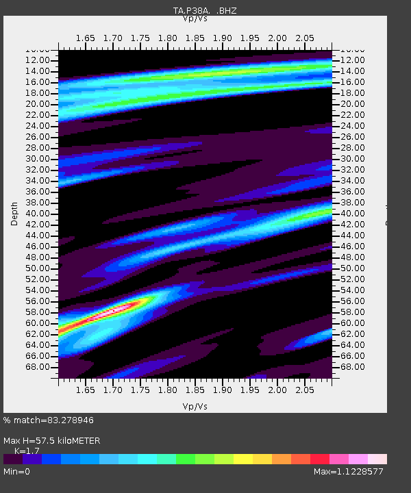
| Estimated Moho Depth: |
57.5 km |
| Estimated Crust Vp/Vs: |
1.70 |
| Assumed Crust Vp: |
6.498 km/s |
| Estimated Crust Vs: |
3.822 km/s |
| Estimated Crust Poisson's Ratio: |
0.24 |
|
| Radial Match: |
83.278946 % |
| Radial Bump: |
272 |
| Transverse Match: |
59.753887 % |
| Transverse Bump: |
327 |
| SOD ConfigId: |
356183 |
| Insert Time: |
2011-10-06 05:53:03.258 +0000 |
| GWidth: |
2.5 |
| Max Bumps: |
400 |
| Tol: |
0.001 |
|

Signal To Noise
| Channel | StoN | STA | LTA |
| TA:P38A: :BHZ:20110430T08:25:30.749993Z | 7.060692 | 5.6046787E-7 | 7.937861E-8 |
| TA:P38A: :BHN:20110430T08:25:30.749993Z | 2.7041159 | 3.490443E-7 | 1.290789E-7 |
| TA:P38A: :BHE:20110430T08:25:30.749993Z | 2.725445 | 1.9649008E-7 | 7.209467E-8 |
| Arrivals |
| Ps | 6.7 SECOND |
| PpPs | 22 SECOND |
| PsPs/PpSs | 29 SECOND |


