You are here: Home > Network List > TA - USArray Transportable Network (new EarthScope stations) Stations List
> Station O39A Kirksville, MO, USA > Earthquake Result Viewer
O39A Kirksville, MO, USA - Earthquake Result Viewer
| Earthquake location: |
South Of Panama |
| Earthquake latitude/longitude: |
6.9/-82.3 |
| Earthquake time(UTC): |
2011/04/30 (120) 08:19:16 GMT |
| Earthquake Depth: |
8.0 km |
| Earthquake Magnitude: |
5.8 MB, 5.7 MS, 6.2 MW, 6.0 MW |
| Earthquake Catalog/Contributor: |
WHDF/NEIC |
|
| Network: |
TA USArray Transportable Network (new EarthScope stations) |
| Station: |
O39A Kirksville, MO, USA |
| Lat/Lon: |
40.25 N/92.54 W |
| Elevation: |
282 m |
|
| Distance: |
34.5 deg |
| Az: |
346.14 deg |
| Baz: |
161.893 deg |
| Ray Param: |
0.07771627 |
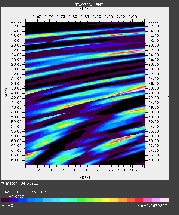
| Estimated Moho Depth: |
38.75 km |
| Estimated Crust Vp/Vs: |
2.06 |
| Assumed Crust Vp: |
6.498 km/s |
| Estimated Crust Vs: |
3.15 km/s |
| Estimated Crust Poisson's Ratio: |
0.35 |
|
| Radial Match: |
84.53901 % |
| Radial Bump: |
400 |
| Transverse Match: |
57.893932 % |
| Transverse Bump: |
400 |
| SOD ConfigId: |
356183 |
| Insert Time: |
2011-10-06 05:54:45.325 +0000 |
| GWidth: |
2.5 |
| Max Bumps: |
400 |
| Tol: |
0.001 |
|

Signal To Noise
| Channel | StoN | STA | LTA |
| TA:O39A: :BHZ:20110430T08:25:33.724999Z | 10.373628 | 9.3521555E-7 | 9.0153186E-8 |
| TA:O39A: :BHN:20110430T08:25:33.724999Z | 8.415875 | 8.3799347E-7 | 9.957294E-8 |
| TA:O39A: :BHE:20110430T08:25:33.724999Z | 2.89514 | 3.056839E-7 | 1.0558519E-7 |
| Arrivals |
| Ps | 6.8 SECOND |
| PpPs | 17 SECOND |
| PsPs/PpSs | 24 SECOND |


