You are here: Home > Network List > US - United States National Seismic Network Stations List
> Station LKWY Lake (Yellowstone--Lake), Wyoming, USA > Earthquake Result Viewer
LKWY Lake (Yellowstone--Lake), Wyoming, USA - Earthquake Result Viewer
| Earthquake location: |
South Of Panama |
| Earthquake latitude/longitude: |
6.9/-82.3 |
| Earthquake time(UTC): |
2011/04/30 (120) 08:19:16 GMT |
| Earthquake Depth: |
8.0 km |
| Earthquake Magnitude: |
5.8 MB, 5.7 MS, 6.2 MW, 6.0 MW |
| Earthquake Catalog/Contributor: |
WHDF/NEIC |
|
| Network: |
US United States National Seismic Network |
| Station: |
LKWY Lake (Yellowstone--Lake), Wyoming, USA |
| Lat/Lon: |
44.57 N/110.40 W |
| Elevation: |
2424 m |
|
| Distance: |
44.8 deg |
| Az: |
331.509 deg |
| Baz: |
138.498 deg |
| Ray Param: |
0.07167868 |
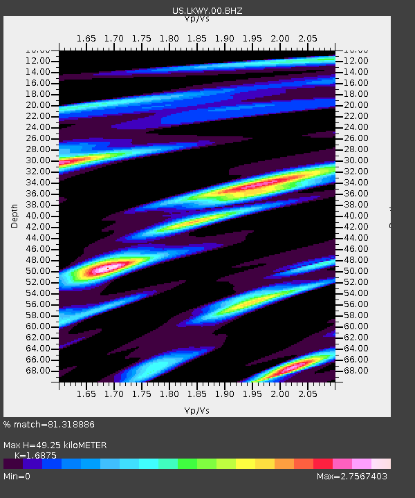
| Estimated Moho Depth: |
49.25 km |
| Estimated Crust Vp/Vs: |
1.69 |
| Assumed Crust Vp: |
6.35 km/s |
| Estimated Crust Vs: |
3.763 km/s |
| Estimated Crust Poisson's Ratio: |
0.23 |
|
| Radial Match: |
81.318886 % |
| Radial Bump: |
400 |
| Transverse Match: |
71.9874 % |
| Transverse Bump: |
400 |
| SOD ConfigId: |
356183 |
| Insert Time: |
2011-10-06 06:03:47.160 +0000 |
| GWidth: |
2.5 |
| Max Bumps: |
400 |
| Tol: |
0.001 |
|
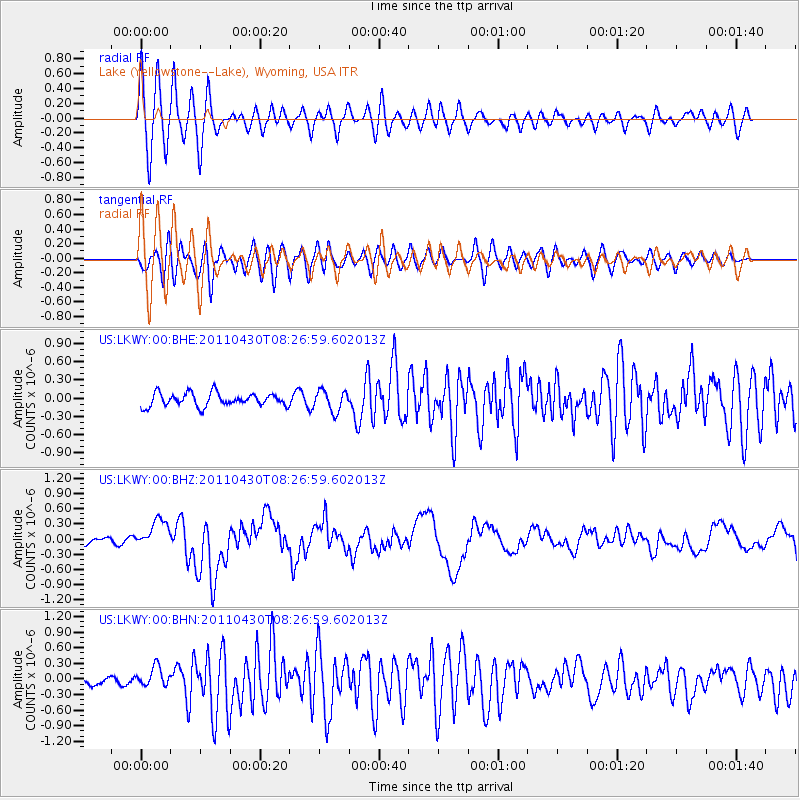
Signal To Noise
| Channel | StoN | STA | LTA |
| US:LKWY:00:BHZ:20110430T08:26:59.602013Z | 3.515679 | 2.7729968E-7 | 7.887514E-8 |
| US:LKWY:00:BHN:20110430T08:26:59.602013Z | 1.9261727 | 1.8658294E-7 | 9.686718E-8 |
| US:LKWY:00:BHE:20110430T08:26:59.602013Z | 1.5793196 | 1.7029576E-7 | 1.0782856E-7 |
| Arrivals |
| Ps | 5.7 SECOND |
| PpPs | 20 SECOND |
| PsPs/PpSs | 25 SECOND |


