You are here: Home > Network List > US - United States National Seismic Network Stations List
> Station HAWA Hanford, Washington, USA > Earthquake Result Viewer
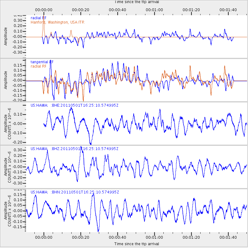
HAWA Hanford, Washington, USA - Earthquake Result Viewer
*The percent match for this event was below the threshold and hence no stack was calculated.
| Earthquake location: |
Solomon Islands |
| Earthquake latitude/longitude: |
-7.0/155.9 |
| Earthquake time(UTC): |
2011/05/01 (121) 16:12:42 GMT |
| Earthquake Depth: |
55 km |
| Earthquake Magnitude: |
5.8 MB, 5.9 MW, 5.8 MW |
| Earthquake Catalog/Contributor: |
WHDF/NEIC |
|
| Network: |
US United States National Seismic Network |
| Station: |
HAWA Hanford, Washington, USA |
| Lat/Lon: |
46.39 N/119.53 W |
| Elevation: |
364 m |
|
| Distance: |
91.3 deg |
| Az: |
43.571 deg |
| Baz: |
261.339 deg |
| Ray Param: |
$rayparam |
*The percent match for this event was below the threshold and hence was not used in the summary stack. |
|
| Radial Match: |
46.05608 % |
| Radial Bump: |
400 |
| Transverse Match: |
58.710377 % |
| Transverse Bump: |
400 |
| SOD ConfigId: |
356183 |
| Insert Time: |
2011-10-06 06:39:42.047 +0000 |
| GWidth: |
2.5 |
| Max Bumps: |
400 |
| Tol: |
0.001 |
|
Signal To Noise
| Channel | StoN | STA | LTA |
| US:HAWA: :BHZ:20110501T16:25:10.574995Z | 1.5754474 | 1.3007659E-7 | 8.256485E-8 |
| US:HAWA: :BHN:20110501T16:25:10.574995Z | 1.5375197 | 6.791777E-8 | 4.417359E-8 |
| US:HAWA: :BHE:20110501T16:25:10.574995Z | 0.75701755 | 5.645833E-8 | 7.457995E-8 |
| Arrivals |
| Ps | |
| PpPs | |
| PsPs/PpSs | |


