You are here: Home > Network List > GH - Ghana Digital Seismic Network Stations List
> Station KUKU Kukurantumi, Ghana > Earthquake Result Viewer
KUKU Kukurantumi, Ghana - Earthquake Result Viewer
| Earthquake location: |
Near Coast Of Peru |
| Earthquake latitude/longitude: |
-14.1/-76.3 |
| Earthquake time(UTC): |
2014/03/15 (074) 08:59:21 GMT |
| Earthquake Depth: |
20 km |
| Earthquake Magnitude: |
6.1 MWW, 6.0 MWB, 6.2 MWC |
| Earthquake Catalog/Contributor: |
NEIC PDE/NEIC COMCAT |
|
| Network: |
GH Ghana Digital Seismic Network |
| Station: |
KUKU Kukurantumi, Ghana |
| Lat/Lon: |
6.19 N/0.37 W |
| Elevation: |
240 m |
|
| Distance: |
78.0 deg |
| Az: |
80.441 deg |
| Baz: |
254.226 deg |
| Ray Param: |
0.04994169 |
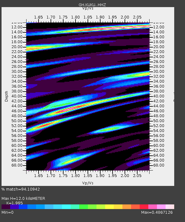
| Estimated Moho Depth: |
12.0 km |
| Estimated Crust Vp/Vs: |
2.00 |
| Assumed Crust Vp: |
6.419 km/s |
| Estimated Crust Vs: |
3.218 km/s |
| Estimated Crust Poisson's Ratio: |
0.33 |
|
| Radial Match: |
94.10942 % |
| Radial Bump: |
270 |
| Transverse Match: |
79.191025 % |
| Transverse Bump: |
400 |
| SOD ConfigId: |
3390531 |
| Insert Time: |
2019-04-10 16:15:13.289 +0000 |
| GWidth: |
2.5 |
| Max Bumps: |
400 |
| Tol: |
0.001 |
|

Signal To Noise
| Channel | StoN | STA | LTA |
| GH:KUKU: :HHZ:20140315T09:10:47.32002Z | 17.514164 | 1.5786156E-6 | 9.0133646E-8 |
| GH:KUKU: :HHN:20140315T09:10:47.32002Z | 2.9040902 | 1.9607828E-7 | 6.751797E-8 |
| GH:KUKU: :HHE:20140315T09:10:47.32002Z | 11.391501 | 5.472302E-7 | 4.803846E-8 |
| Arrivals |
| Ps | 1.9 SECOND |
| PpPs | 5.5 SECOND |
| PsPs/PpSs | 7.4 SECOND |


