You are here: Home > Network List > TA - USArray Transportable Network (new EarthScope stations) Stations List
> Station 234A Clairette, TX, USA > Earthquake Result Viewer
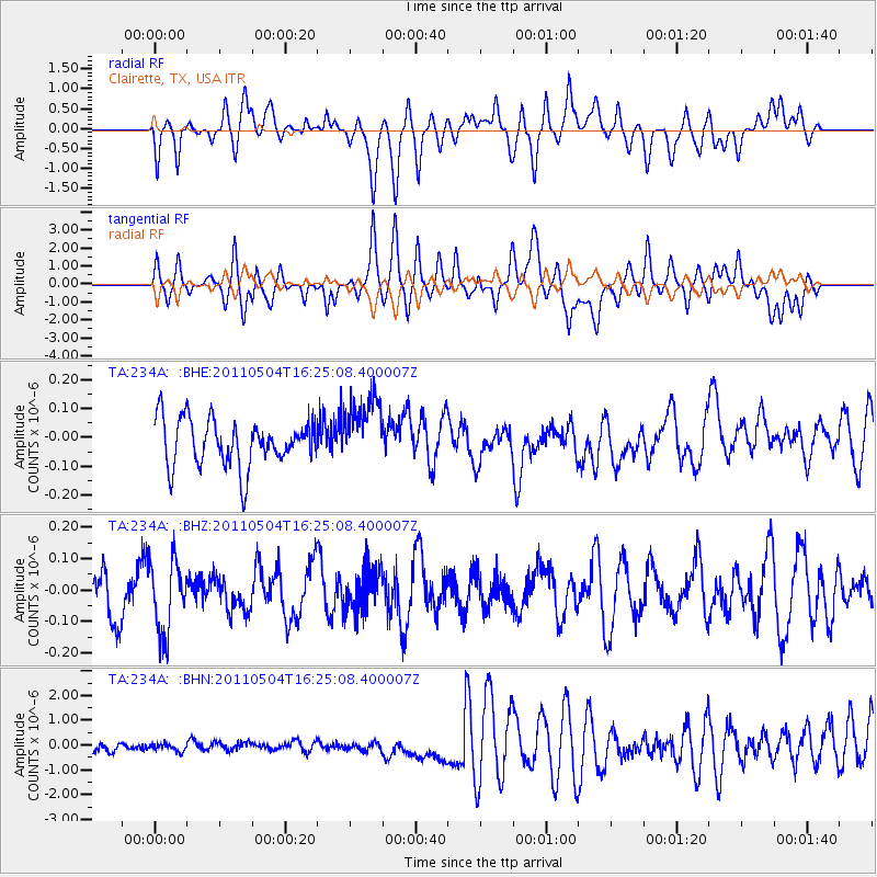
234A Clairette, TX, USA - Earthquake Result Viewer
*The percent match for this event was below the threshold and hence no stack was calculated.
| Earthquake location: |
Fiji Islands Region |
| Earthquake latitude/longitude: |
-20.4/-178.5 |
| Earthquake time(UTC): |
2011/05/04 (124) 16:13:28 GMT |
| Earthquake Depth: |
584 km |
| Earthquake Magnitude: |
5.6 MW, 5.2 MB, 5.6 MW |
| Earthquake Catalog/Contributor: |
WHDF/NEIC |
|
| Network: |
TA USArray Transportable Network (new EarthScope stations) |
| Station: |
234A Clairette, TX, USA |
| Lat/Lon: |
32.00 N/98.14 W |
| Elevation: |
358 m |
|
| Distance: |
92.9 deg |
| Az: |
57.012 deg |
| Baz: |
247.837 deg |
| Ray Param: |
$rayparam |
*The percent match for this event was below the threshold and hence was not used in the summary stack. |
|
| Radial Match: |
51.257217 % |
| Radial Bump: |
400 |
| Transverse Match: |
47.50428 % |
| Transverse Bump: |
400 |
| SOD ConfigId: |
356183 |
| Insert Time: |
2011-10-06 07:30:41.266 +0000 |
| GWidth: |
2.5 |
| Max Bumps: |
400 |
| Tol: |
0.001 |
|
Signal To Noise
| Channel | StoN | STA | LTA |
| TA:234A: :BHZ:20110504T16:25:08.400007Z | 1.7450576 | 1.12943226E-7 | 6.4721775E-8 |
| TA:234A: :BHN:20110504T16:25:08.400007Z | 0.26145235 | 2.0819704E-7 | 7.963097E-7 |
| TA:234A: :BHE:20110504T16:25:08.400007Z | 1.4203666 | 1.15069064E-7 | 8.101363E-8 |
| Arrivals |
| Ps | |
| PpPs | |
| PsPs/PpSs | |


