You are here: Home > Network List > PR - Puerto Rico Seismic Network (PRSN) & Puerto Rico Strong Motion Program (PRSMP) Stations List
> Station OBIP Ponce, Puerto Rico(T4125) > Earthquake Result Viewer
OBIP Ponce, Puerto Rico(T4125) - Earthquake Result Viewer
| Earthquake location: |
Near Coast Of Peru |
| Earthquake latitude/longitude: |
-14.1/-76.3 |
| Earthquake time(UTC): |
2014/03/15 (074) 08:59:21 GMT |
| Earthquake Depth: |
20 km |
| Earthquake Magnitude: |
6.1 MWW, 6.0 MWB, 6.2 MWC |
| Earthquake Catalog/Contributor: |
NEIC PDE/NEIC COMCAT |
|
| Network: |
PR Puerto Rico Seismic Network (PRSN) & Puerto Rico Strong Motion Program (PRSMP) |
| Station: |
OBIP Ponce, Puerto Rico(T4125) |
| Lat/Lon: |
18.04 N/66.61 W |
| Elevation: |
103 m |
|
| Distance: |
33.3 deg |
| Az: |
16.964 deg |
| Baz: |
197.31 deg |
| Ray Param: |
0.07823233 |
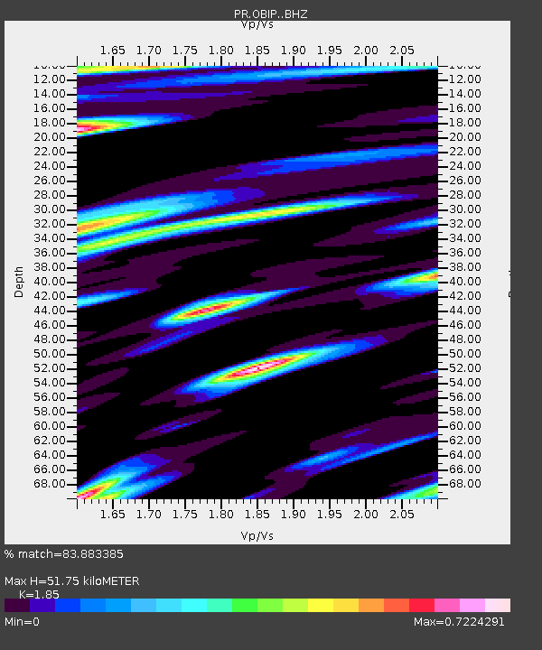
| Estimated Moho Depth: |
51.75 km |
| Estimated Crust Vp/Vs: |
1.85 |
| Assumed Crust Vp: |
5.14 km/s |
| Estimated Crust Vs: |
2.778 km/s |
| Estimated Crust Poisson's Ratio: |
0.29 |
|
| Radial Match: |
83.883385 % |
| Radial Bump: |
400 |
| Transverse Match: |
70.64657 % |
| Transverse Bump: |
400 |
| SOD ConfigId: |
3390531 |
| Insert Time: |
2019-04-10 16:16:51.768 +0000 |
| GWidth: |
2.5 |
| Max Bumps: |
400 |
| Tol: |
0.001 |
|

Signal To Noise
| Channel | StoN | STA | LTA |
| PR:OBIP: :BHZ:20140315T09:05:27.639996Z | 12.204682 | 2.0933883E-6 | 1.7152338E-7 |
| PR:OBIP: :BHN:20140315T09:05:27.639996Z | 6.167417 | 9.963165E-7 | 1.615452E-7 |
| PR:OBIP: :BHE:20140315T09:05:27.639996Z | 3.904898 | 5.108574E-7 | 1.3082477E-7 |
| Arrivals |
| Ps | 9.0 SECOND |
| PpPs | 27 SECOND |
| PsPs/PpSs | 36 SECOND |


