You are here: Home > Network List > TA - USArray Transportable Network (new EarthScope stations) Stations List
> Station TPFO Pinon Flats, CA, USA > Earthquake Result Viewer
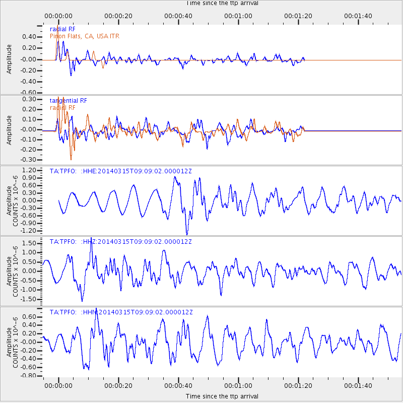
TPFO Pinon Flats, CA, USA - Earthquake Result Viewer
*The percent match for this event was below the threshold and hence no stack was calculated.
| Earthquake location: |
Near Coast Of Peru |
| Earthquake latitude/longitude: |
-14.1/-76.3 |
| Earthquake time(UTC): |
2014/03/15 (074) 08:59:21 GMT |
| Earthquake Depth: |
20 km |
| Earthquake Magnitude: |
6.1 MWW, 6.0 MWB, 6.2 MWC |
| Earthquake Catalog/Contributor: |
NEIC PDE/NEIC COMCAT |
|
| Network: |
TA USArray Transportable Network (new EarthScope stations) |
| Station: |
TPFO Pinon Flats, CA, USA |
| Lat/Lon: |
33.61 N/116.45 W |
| Elevation: |
1275 m |
|
| Distance: |
60.9 deg |
| Az: |
322.009 deg |
| Baz: |
134.305 deg |
| Ray Param: |
$rayparam |
*The percent match for this event was below the threshold and hence was not used in the summary stack. |
|
| Radial Match: |
73.30237 % |
| Radial Bump: |
400 |
| Transverse Match: |
87.53983 % |
| Transverse Bump: |
357 |
| SOD ConfigId: |
3390531 |
| Insert Time: |
2019-04-10 16:17:33.456 +0000 |
| GWidth: |
2.5 |
| Max Bumps: |
400 |
| Tol: |
0.001 |
|
Signal To Noise
| Channel | StoN | STA | LTA |
| TA:TPFO: :HHZ:20140315T09:09:02.000012Z | 1.4277363 | 5.562536E-7 | 3.896053E-7 |
| TA:TPFO: :HHN:20140315T09:09:02.000012Z | 1.2203897 | 1.6155711E-7 | 1.3238157E-7 |
| TA:TPFO: :HHE:20140315T09:09:02.000012Z | 1.0100768 | 3.0578633E-7 | 3.027357E-7 |
| Arrivals |
| Ps | |
| PpPs | |
| PsPs/PpSs | |


