You are here: Home > Network List > XB14 - Sweetwater Array Stations List
> Station C0319 991001 > Earthquake Result Viewer
C0319 991001 - Earthquake Result Viewer
| Earthquake location: |
Near Coast Of Peru |
| Earthquake latitude/longitude: |
-14.1/-76.3 |
| Earthquake time(UTC): |
2014/03/15 (074) 08:59:21 GMT |
| Earthquake Depth: |
20 km |
| Earthquake Magnitude: |
6.1 MWW, 6.0 MWB, 6.2 MWC |
| Earthquake Catalog/Contributor: |
NEIC PDE/NEIC COMCAT |
|
| Network: |
XB Sweetwater Array |
| Station: |
C0319 991001 |
| Lat/Lon: |
32.73 N/100.64 W |
| Elevation: |
633 m |
|
| Distance: |
52.0 deg |
| Az: |
333.867 deg |
| Baz: |
149.535 deg |
| Ray Param: |
0.06698454 |
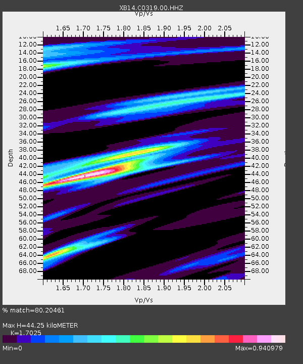
| Estimated Moho Depth: |
44.25 km |
| Estimated Crust Vp/Vs: |
1.70 |
| Assumed Crust Vp: |
6.426 km/s |
| Estimated Crust Vs: |
3.775 km/s |
| Estimated Crust Poisson's Ratio: |
0.24 |
|
| Radial Match: |
80.20461 % |
| Radial Bump: |
400 |
| Transverse Match: |
53.048233 % |
| Transverse Bump: |
394 |
| SOD ConfigId: |
3390531 |
| Insert Time: |
2019-04-10 16:18:46.398 +0000 |
| GWidth: |
2.5 |
| Max Bumps: |
400 |
| Tol: |
0.001 |
|

Signal To Noise
| Channel | StoN | STA | LTA |
| XB:C0319:00:HHZ:20140315T09:07:58.82002Z | 3.2736216 | 5.0315174E-7 | 1.536988E-7 |
| XB:C0319:00:HH1:20140315T09:07:58.82002Z | 1.2346747 | 1.8531273E-7 | 1.5009033E-7 |
| XB:C0319:00:HH2:20140315T09:07:58.82002Z | 0.83436644 | 1.4791318E-7 | 1.7727605E-7 |
| Arrivals |
| Ps | 5.1 SECOND |
| PpPs | 18 SECOND |
| PsPs/PpSs | 23 SECOND |


