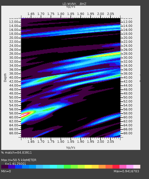
WVNY West Valley, New York - Earthquake Result Viewer

Earthquake location: Near Coast Of Guerrero, Mexico
Earthquake latitude/longitude: 16.8/-98.6
Earthquake time(UTC): 2011/05/05 (125) 13:24:07 GMT
Earthquake Depth: 24 km
Earthquake Magnitude: 5.7 MW, 5.4 MS, 5.4 MB, 5.5 MW
Earthquake Catalog/Contributor: WHDF/NEIC
Network: LD Lamont-Doherty Cooperative Seismographic Network
Station: WVNY West Valley, New York
Lat/Lon: 42.41 N/78.60 W
Elevation: 490 m
Distance: 30.7 deg
Az: 29.726 deg
Baz: 219.892 deg
Ray Param: 0.07923378
Estimated Moho Depth: 58.5 km
Estimated Crust Vp/Vs: 1.61
Assumed Crust Vp: 6.419 km/s
Estimated Crust Vs: 3.981 km/s
Estimated Crust Poisson's Ratio: 0.19
Radial Match: 84.83911 %
Radial Bump: 400
Transverse Match: 58.022484 %
Transverse Bump: 400
SOD ConfigId: 356183
Insert Time: 2011-10-06 08:11:50.208 +0000
GWidth: 2.5
Max Bumps: 400
Tol: 0.001

Signal To Noise

ChannelStoNSTALTA
LD:WVNY: :BHZ:20110505T13:29:50.565006Z6.69928369.0747454E-71.3545845E-7
LD:WVNY: :BHN:20110505T13:29:50.565006Z2.79239424.990793E-71.7872811E-7
LD:WVNY: :BHE:20110505T13:29:50.565006Z3.34745264.5717294E-71.3657339E-7
Arrivals
Ps6.1 SECOND
PpPs22 SECOND
PsPs/PpSs28 SECOND