You are here: Home > Network List > TA - USArray Transportable Network (new EarthScope stations) Stations List
> Station B30A Myrvik Farm, Edmore, ND, USA > Earthquake Result Viewer
B30A Myrvik Farm, Edmore, ND, USA - Earthquake Result Viewer
| Earthquake location: |
Near Coast Of Guerrero, Mexico |
| Earthquake latitude/longitude: |
16.8/-98.6 |
| Earthquake time(UTC): |
2011/05/05 (125) 13:24:07 GMT |
| Earthquake Depth: |
24 km |
| Earthquake Magnitude: |
5.7 MW, 5.4 MS, 5.4 MB, 5.5 MW |
| Earthquake Catalog/Contributor: |
WHDF/NEIC |
|
| Network: |
TA USArray Transportable Network (new EarthScope stations) |
| Station: |
B30A Myrvik Farm, Edmore, ND, USA |
| Lat/Lon: |
48.45 N/98.33 W |
| Elevation: |
480 m |
|
| Distance: |
31.6 deg |
| Az: |
0.368 deg |
| Baz: |
180.529 deg |
| Ray Param: |
0.07898655 |
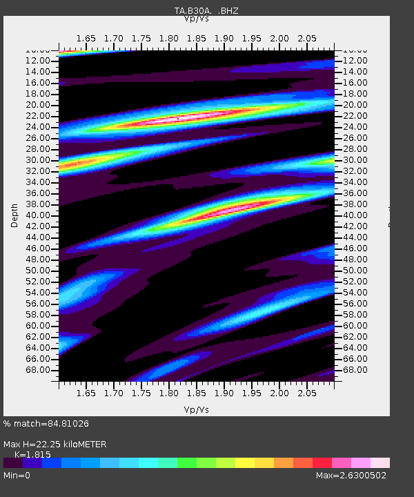
| Estimated Moho Depth: |
22.25 km |
| Estimated Crust Vp/Vs: |
1.82 |
| Assumed Crust Vp: |
6.53 km/s |
| Estimated Crust Vs: |
3.598 km/s |
| Estimated Crust Poisson's Ratio: |
0.28 |
|
| Radial Match: |
84.81026 % |
| Radial Bump: |
400 |
| Transverse Match: |
72.29952 % |
| Transverse Bump: |
400 |
| SOD ConfigId: |
356183 |
| Insert Time: |
2011-10-06 08:28:54.236 +0000 |
| GWidth: |
2.5 |
| Max Bumps: |
400 |
| Tol: |
0.001 |
|

Signal To Noise
| Channel | StoN | STA | LTA |
| TA:B30A: :BHZ:20110505T13:29:57.949985Z | 5.4587955 | 6.239817E-7 | 1.1430758E-7 |
| TA:B30A: :BHN:20110505T13:29:57.949985Z | 3.335135 | 7.236631E-7 | 2.1698166E-7 |
| TA:B30A: :BHE:20110505T13:29:57.949985Z | 1.1058785 | 1.07794236E-7 | 9.747385E-8 |
| Arrivals |
| Ps | 3.0 SECOND |
| PpPs | 8.8 SECOND |
| PsPs/PpSs | 12 SECOND |


