You are here: Home > Network List > TA - USArray Transportable Network (new EarthScope stations) Stations List
> Station I03D Drain, OR, USA > Earthquake Result Viewer
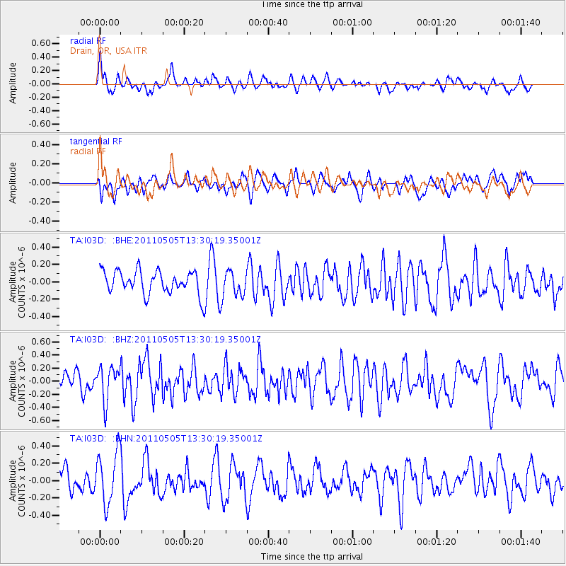
I03D Drain, OR, USA - Earthquake Result Viewer
*The percent match for this event was below the threshold and hence no stack was calculated.
| Earthquake location: |
Near Coast Of Guerrero, Mexico |
| Earthquake latitude/longitude: |
16.8/-98.6 |
| Earthquake time(UTC): |
2011/05/05 (125) 13:24:07 GMT |
| Earthquake Depth: |
24 km |
| Earthquake Magnitude: |
5.7 MW, 5.4 MS, 5.4 MB, 5.5 MW |
| Earthquake Catalog/Contributor: |
WHDF/NEIC |
|
| Network: |
TA USArray Transportable Network (new EarthScope stations) |
| Station: |
I03D Drain, OR, USA |
| Lat/Lon: |
43.70 N/123.35 W |
| Elevation: |
140 m |
|
| Distance: |
34.0 deg |
| Az: |
327.175 deg |
| Baz: |
134.281 deg |
| Ray Param: |
$rayparam |
*The percent match for this event was below the threshold and hence was not used in the summary stack. |
|
| Radial Match: |
63.76217 % |
| Radial Bump: |
400 |
| Transverse Match: |
45.110954 % |
| Transverse Bump: |
400 |
| SOD ConfigId: |
356183 |
| Insert Time: |
2011-10-06 08:31:08.795 +0000 |
| GWidth: |
2.5 |
| Max Bumps: |
400 |
| Tol: |
0.001 |
|
Signal To Noise
| Channel | StoN | STA | LTA |
| TA:I03D: :BHZ:20110505T13:30:19.35001Z | 2.0826344 | 2.6491114E-7 | 1.2720001E-7 |
| TA:I03D: :BHN:20110505T13:30:19.35001Z | 1.9507669 | 3.0580725E-7 | 1.5676258E-7 |
| TA:I03D: :BHE:20110505T13:30:19.35001Z | 1.0275292 | 1.3736243E-7 | 1.3368226E-7 |
| Arrivals |
| Ps | |
| PpPs | |
| PsPs/PpSs | |


