You are here: Home > Network List > TA - USArray Transportable Network (new EarthScope stations) Stations List
> Station D34A Park Rapids, MN, USA > Earthquake Result Viewer
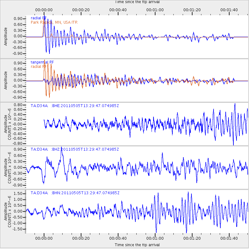
D34A Park Rapids, MN, USA - Earthquake Result Viewer
*The percent match for this event was below the threshold and hence no stack was calculated.
| Earthquake location: |
Near Coast Of Guerrero, Mexico |
| Earthquake latitude/longitude: |
16.8/-98.6 |
| Earthquake time(UTC): |
2011/05/05 (125) 13:24:07 GMT |
| Earthquake Depth: |
24 km |
| Earthquake Magnitude: |
5.7 MW, 5.4 MS, 5.4 MB, 5.5 MW |
| Earthquake Catalog/Contributor: |
WHDF/NEIC |
|
| Network: |
TA USArray Transportable Network (new EarthScope stations) |
| Station: |
D34A Park Rapids, MN, USA |
| Lat/Lon: |
47.09 N/95.20 W |
| Elevation: |
476 m |
|
| Distance: |
30.3 deg |
| Az: |
4.632 deg |
| Baz: |
186.5 deg |
| Ray Param: |
$rayparam |
*The percent match for this event was below the threshold and hence was not used in the summary stack. |
|
| Radial Match: |
66.27092 % |
| Radial Bump: |
400 |
| Transverse Match: |
60.70163 % |
| Transverse Bump: |
400 |
| SOD ConfigId: |
356183 |
| Insert Time: |
2011-10-06 08:37:02.183 +0000 |
| GWidth: |
2.5 |
| Max Bumps: |
400 |
| Tol: |
0.001 |
|
Signal To Noise
| Channel | StoN | STA | LTA |
| TA:D34A: :BHZ:20110505T13:29:47.074985Z | 3.4453545 | 4.0403734E-7 | 1.17270176E-7 |
| TA:D34A: :BHN:20110505T13:29:47.074985Z | 2.3978338 | 3.1600325E-7 | 1.3178696E-7 |
| TA:D34A: :BHE:20110505T13:29:47.074985Z | 1.1689721 | 1.3362924E-7 | 1.1431345E-7 |
| Arrivals |
| Ps | |
| PpPs | |
| PsPs/PpSs | |


