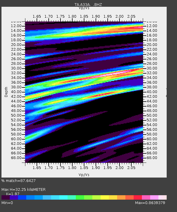
A33A Warroad, MN, USA - Earthquake Result Viewer
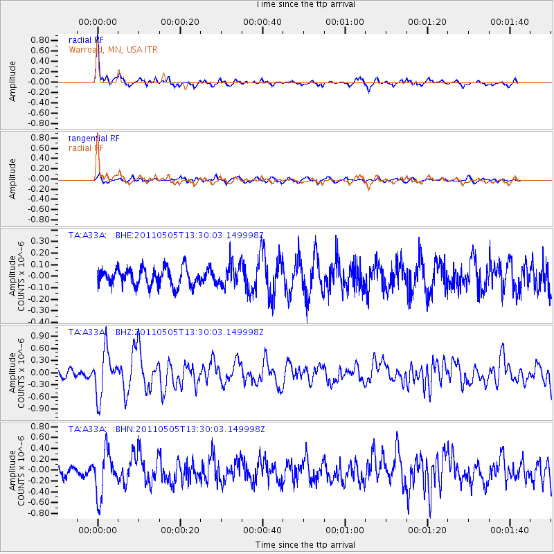
Earthquake location: Near Coast Of Guerrero, Mexico
Earthquake latitude/longitude: 16.8/-98.6
Earthquake time(UTC): 2011/05/05 (125) 13:24:07 GMT
Earthquake Depth: 24 km
Earthquake Magnitude: 5.7 MW, 5.4 MS, 5.4 MB, 5.5 MW
Earthquake Catalog/Contributor: WHDF/NEIC
Network: TA USArray Transportable Network (new EarthScope stations)
Station: A33A Warroad, MN, USA
Lat/Lon: 48.94 N/95.39 W
Elevation: 329 m
Distance: 32.2 deg
Az: 3.998 deg
Baz: 185.813 deg
Ray Param: 0.07873403
Estimated Moho Depth: 32.25 km
Estimated Crust Vp/Vs: 1.97
Assumed Crust Vp: 6.419 km/s
Estimated Crust Vs: 3.258 km/s
Estimated Crust Poisson's Ratio: 0.33
Radial Match: 87.6427 %
Radial Bump: 389
Transverse Match: 55.979866 %
Transverse Bump: 400
SOD ConfigId: 356183
Insert Time: 2011-10-06 08:42:19.814 +0000
GWidth: 2.5
Max Bumps: 400
Tol: 0.001

Signal To Noise

ChannelStoNSTALTA
TA:A33A: :BHZ:20110505T13:30:03.149998Z6.7867595.623803E-78.286434E-8
TA:A33A: :BHN:20110505T13:30:03.149998Z4.63688764.1405028E-78.929487E-8
TA:A33A: :BHE:20110505T13:30:03.149998Z1.28372119.764055E-87.6060566E-8
Arrivals
Ps5.2 SECOND
PpPs14 SECOND
PsPs/PpSs19 SECOND