You are here: Home > Network List > TA - USArray Transportable Network (new EarthScope stations) Stations List
> Station B33A Robert and Kassanda Mosher, Grygla, MN, USA > Earthquake Result Viewer
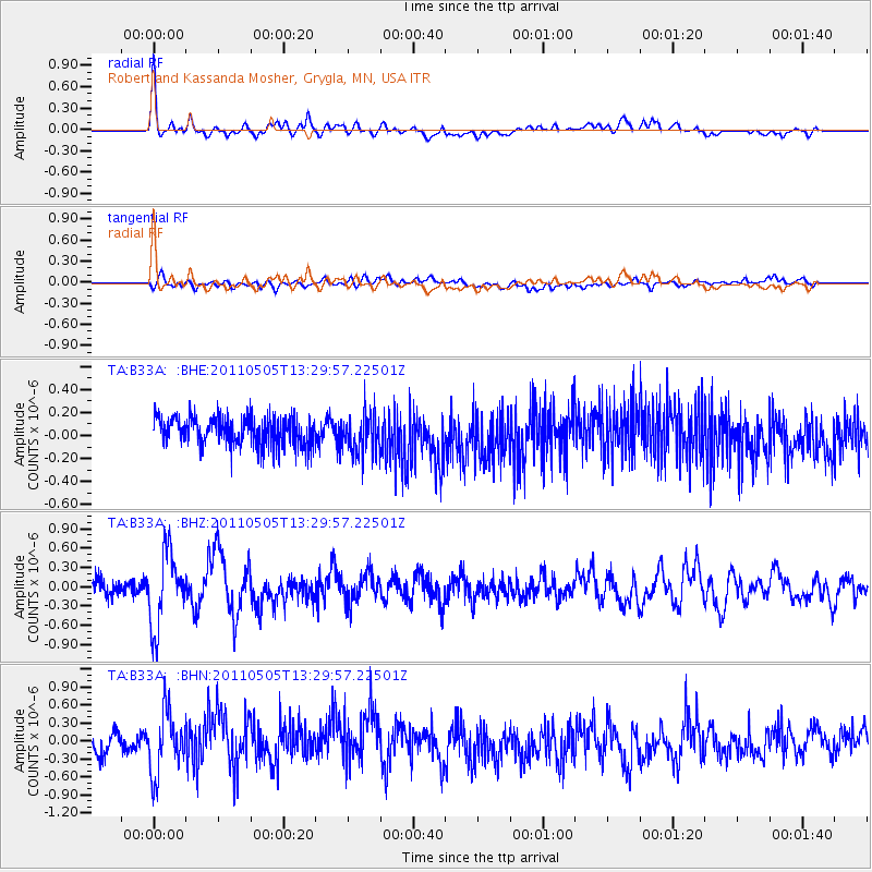
B33A Robert and Kassanda Mosher, Grygla, MN, USA - Earthquake Result Viewer
*The percent match for this event was below the threshold and hence no stack was calculated.
| Earthquake location: |
Near Coast Of Guerrero, Mexico |
| Earthquake latitude/longitude: |
16.8/-98.6 |
| Earthquake time(UTC): |
2011/05/05 (125) 13:24:07 GMT |
| Earthquake Depth: |
24 km |
| Earthquake Magnitude: |
5.7 MW, 5.4 MS, 5.4 MB, 5.5 MW |
| Earthquake Catalog/Contributor: |
WHDF/NEIC |
|
| Network: |
TA USArray Transportable Network (new EarthScope stations) |
| Station: |
B33A Robert and Kassanda Mosher, Grygla, MN, USA |
| Lat/Lon: |
48.27 N/95.59 W |
| Elevation: |
362 m |
|
| Distance: |
31.5 deg |
| Az: |
3.875 deg |
| Baz: |
185.561 deg |
| Ray Param: |
$rayparam |
*The percent match for this event was below the threshold and hence was not used in the summary stack. |
|
| Radial Match: |
76.42825 % |
| Radial Bump: |
400 |
| Transverse Match: |
51.744118 % |
| Transverse Bump: |
400 |
| SOD ConfigId: |
356183 |
| Insert Time: |
2011-10-06 08:44:12.797 +0000 |
| GWidth: |
2.5 |
| Max Bumps: |
400 |
| Tol: |
0.001 |
|
Signal To Noise
| Channel | StoN | STA | LTA |
| TA:B33A: :BHZ:20110505T13:29:57.22501Z | 5.0248547 | 5.783961E-7 | 1.15107035E-7 |
| TA:B33A: :BHN:20110505T13:29:57.22501Z | 3.2441063 | 5.1930056E-7 | 1.6007507E-7 |
| TA:B33A: :BHE:20110505T13:29:57.22501Z | 1.4267404 | 1.7713886E-7 | 1.2415633E-7 |
| Arrivals |
| Ps | |
| PpPs | |
| PsPs/PpSs | |


