You are here: Home > Network List > Z910 - Southeastern Suture of the Appalachian Margin Experiment Stations List
> Station W27 Butler Property, Forsyth, GA > Earthquake Result Viewer
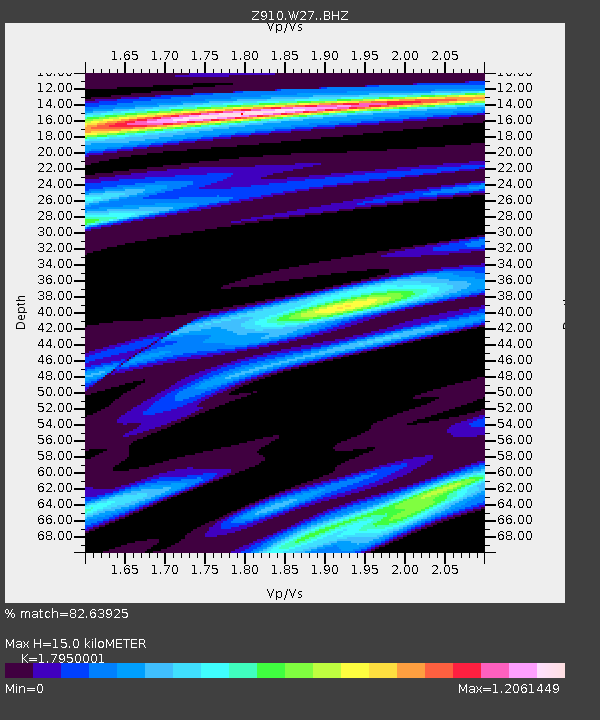
W27 Butler Property, Forsyth, GA - Earthquake Result Viewer
| Earthquake location: |
Near Coast Of Peru |
| Earthquake latitude/longitude: |
-14.1/-76.3 |
| Earthquake time(UTC): |
2014/03/15 (074) 08:59:21 GMT |
| Earthquake Depth: |
20 km |
| Earthquake Magnitude: |
6.1 MWW, 6.0 MWB, 6.2 MWC |
| Earthquake Catalog/Contributor: |
NEIC PDE/NEIC COMCAT |
|
| Network: |
Z9 Southeastern Suture of the Appalachian Margin Experiment |
| Station: |
W27 Butler Property, Forsyth, GA |
| Lat/Lon: |
32.92 N/83.92 W |
| Elevation: |
164 m |
|
| Distance: |
47.3 deg |
| Az: |
351.279 deg |
| Baz: |
169.926 deg |
| Ray Param: |
0.07004758 |
| Estimated Moho Depth: |
15.0 km |
| Estimated Crust Vp/Vs: |
1.80 |
| Assumed Crust Vp: |
6.565 km/s |
| Estimated Crust Vs: |
3.657 km/s |
| Estimated Crust Poisson's Ratio: |
0.27 |
|
| Radial Match: |
82.63925 % |
| Radial Bump: |
314 |
| Transverse Match: |
67.35167 % |
| Transverse Bump: |
400 |
| SOD ConfigId: |
3390531 |
| Insert Time: |
2019-04-10 16:20:53.343 +0000 |
| GWidth: |
2.5 |
| Max Bumps: |
400 |
| Tol: |
0.001 |
|

Signal To Noise
| Channel | StoN | STA | LTA |
| Z9:W27: :BHZ:20140315T09:07:22.879987Z | 7.692466 | 1.3444843E-6 | 1.7477936E-7 |
| Z9:W27: :BHN:20140315T09:07:22.879987Z | 6.271193 | 6.542137E-7 | 1.04320456E-7 |
| Z9:W27: :BHE:20140315T09:07:22.879987Z | 1.018186 | 1.3210365E-7 | 1.2974414E-7 |
| Arrivals |
| Ps | 1.9 SECOND |
| PpPs | 6.0 SECOND |
| PsPs/PpSs | 7.9 SECOND |


