You are here: Home > Network List > TA - USArray Transportable Network (new EarthScope stations) Stations List
> Station H28A Mission Ridge, SD, USA > Earthquake Result Viewer
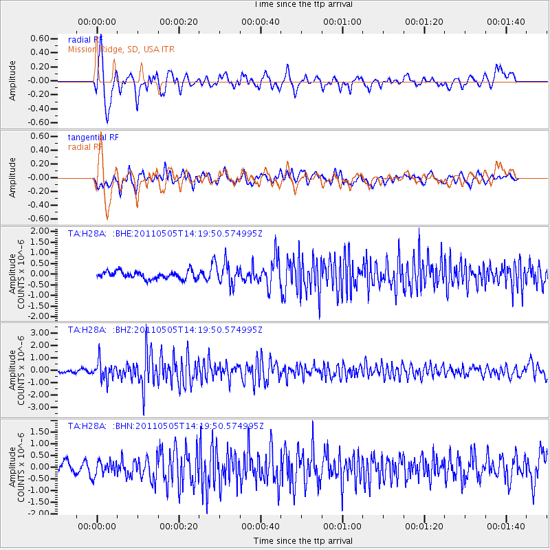
H28A Mission Ridge, SD, USA - Earthquake Result Viewer
*The percent match for this event was below the threshold and hence no stack was calculated.
| Earthquake location: |
Alaska Peninsula |
| Earthquake latitude/longitude: |
55.1/-160.5 |
| Earthquake time(UTC): |
2011/05/05 (125) 14:13:01 GMT |
| Earthquake Depth: |
39 km |
| Earthquake Magnitude: |
5.9 MB, 5.3 MS, 5.7 MW, 5.7 MW |
| Earthquake Catalog/Contributor: |
WHDF/NEIC |
|
| Network: |
TA USArray Transportable Network (new EarthScope stations) |
| Station: |
H28A Mission Ridge, SD, USA |
| Lat/Lon: |
44.68 N/101.02 W |
| Elevation: |
642 m |
|
| Distance: |
38.6 deg |
| Az: |
80.163 deg |
| Baz: |
307.455 deg |
| Ray Param: |
$rayparam |
*The percent match for this event was below the threshold and hence was not used in the summary stack. |
|
| Radial Match: |
77.57944 % |
| Radial Bump: |
400 |
| Transverse Match: |
65.79001 % |
| Transverse Bump: |
400 |
| SOD ConfigId: |
356183 |
| Insert Time: |
2011-10-06 09:44:54.913 +0000 |
| GWidth: |
2.5 |
| Max Bumps: |
400 |
| Tol: |
0.001 |
|
Signal To Noise
| Channel | StoN | STA | LTA |
| TA:H28A: :BHZ:20110505T14:19:50.574995Z | 8.555637 | 7.3440634E-7 | 8.5838884E-8 |
| TA:H28A: :BHN:20110505T14:19:50.574995Z | 1.0416938 | 2.9755643E-7 | 2.8564673E-7 |
| TA:H28A: :BHE:20110505T14:19:50.574995Z | 2.8430567 | 5.02979E-7 | 1.7691485E-7 |
| Arrivals |
| Ps | |
| PpPs | |
| PsPs/PpSs | |


