You are here: Home > Network List > TA - USArray Transportable Network (new EarthScope stations) Stations List
> Station 234A Clairette, TX, USA > Earthquake Result Viewer
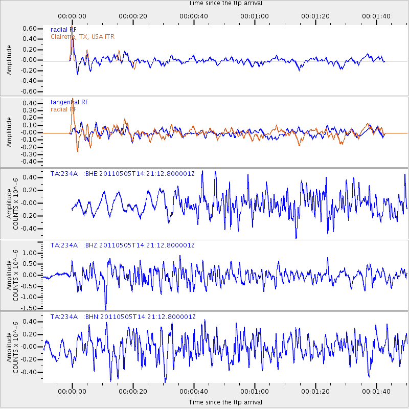
234A Clairette, TX, USA - Earthquake Result Viewer
*The percent match for this event was below the threshold and hence no stack was calculated.
| Earthquake location: |
Alaska Peninsula |
| Earthquake latitude/longitude: |
55.1/-160.5 |
| Earthquake time(UTC): |
2011/05/05 (125) 14:13:01 GMT |
| Earthquake Depth: |
39 km |
| Earthquake Magnitude: |
5.9 MB, 5.3 MS, 5.7 MW, 5.7 MW |
| Earthquake Catalog/Contributor: |
WHDF/NEIC |
|
| Network: |
TA USArray Transportable Network (new EarthScope stations) |
| Station: |
234A Clairette, TX, USA |
| Lat/Lon: |
32.00 N/98.14 W |
| Elevation: |
358 m |
|
| Distance: |
48.9 deg |
| Az: |
91.439 deg |
| Baz: |
317.44 deg |
| Ray Param: |
$rayparam |
*The percent match for this event was below the threshold and hence was not used in the summary stack. |
|
| Radial Match: |
74.65716 % |
| Radial Bump: |
400 |
| Transverse Match: |
64.57145 % |
| Transverse Bump: |
400 |
| SOD ConfigId: |
356183 |
| Insert Time: |
2011-10-06 10:09:39.183 +0000 |
| GWidth: |
2.5 |
| Max Bumps: |
400 |
| Tol: |
0.001 |
|
Signal To Noise
| Channel | StoN | STA | LTA |
| TA:234A: :BHZ:20110505T14:21:12.800001Z | 3.0215452 | 3.425874E-7 | 1.1338153E-7 |
| TA:234A: :BHN:20110505T14:21:12.800001Z | 1.4098833 | 1.5178678E-7 | 1.07659105E-7 |
| TA:234A: :BHE:20110505T14:21:12.800001Z | 1.8953834 | 1.9121305E-7 | 1.00883575E-7 |
| Arrivals |
| Ps | |
| PpPs | |
| PsPs/PpSs | |


