You are here: Home > Network List > TA - USArray Transportable Network (new EarthScope stations) Stations List
> Station 136A Ennis, TX, USA > Earthquake Result Viewer
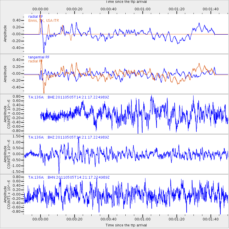
136A Ennis, TX, USA - Earthquake Result Viewer
*The percent match for this event was below the threshold and hence no stack was calculated.
| Earthquake location: |
Alaska Peninsula |
| Earthquake latitude/longitude: |
55.1/-160.5 |
| Earthquake time(UTC): |
2011/05/05 (125) 14:13:01 GMT |
| Earthquake Depth: |
39 km |
| Earthquake Magnitude: |
5.9 MB, 5.3 MS, 5.7 MW, 5.7 MW |
| Earthquake Catalog/Contributor: |
WHDF/NEIC |
|
| Network: |
TA USArray Transportable Network (new EarthScope stations) |
| Station: |
136A Ennis, TX, USA |
| Lat/Lon: |
32.47 N/96.53 W |
| Elevation: |
113 m |
|
| Distance: |
49.4 deg |
| Az: |
89.695 deg |
| Baz: |
317.153 deg |
| Ray Param: |
$rayparam |
*The percent match for this event was below the threshold and hence was not used in the summary stack. |
|
| Radial Match: |
68.136635 % |
| Radial Bump: |
400 |
| Transverse Match: |
57.915443 % |
| Transverse Bump: |
400 |
| SOD ConfigId: |
356183 |
| Insert Time: |
2011-10-06 10:28:50.271 +0000 |
| GWidth: |
2.5 |
| Max Bumps: |
400 |
| Tol: |
0.001 |
|
Signal To Noise
| Channel | StoN | STA | LTA |
| TA:136A: :BHZ:20110505T14:21:17.224989Z | 2.5365062 | 3.7642621E-7 | 1.4840344E-7 |
| TA:136A: :BHN:20110505T14:21:17.224989Z | 1.1194258 | 2.883079E-7 | 2.575498E-7 |
| TA:136A: :BHE:20110505T14:21:17.224989Z | 1.7204907 | 2.9455728E-7 | 1.7120539E-7 |
| Arrivals |
| Ps | |
| PpPs | |
| PsPs/PpSs | |


