You are here: Home > Network List > TA - USArray Transportable Network (new EarthScope stations) Stations List
> Station K34A Le Mars, IA, USA > Earthquake Result Viewer
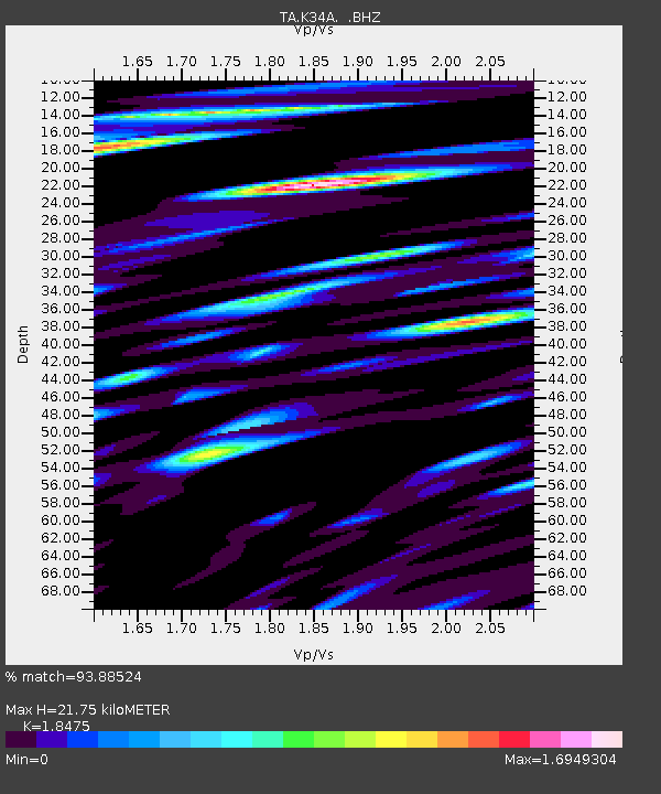
K34A Le Mars, IA, USA - Earthquake Result Viewer
| Earthquake location: |
Alaska Peninsula |
| Earthquake latitude/longitude: |
55.1/-160.5 |
| Earthquake time(UTC): |
2011/05/05 (125) 14:13:01 GMT |
| Earthquake Depth: |
39 km |
| Earthquake Magnitude: |
5.9 MB, 5.3 MS, 5.7 MW, 5.7 MW |
| Earthquake Catalog/Contributor: |
WHDF/NEIC |
|
| Network: |
TA USArray Transportable Network (new EarthScope stations) |
| Station: |
K34A Le Mars, IA, USA |
| Lat/Lon: |
42.69 N/96.10 W |
| Elevation: |
436 m |
|
| Distance: |
42.6 deg |
| Az: |
79.108 deg |
| Baz: |
310.045 deg |
| Ray Param: |
0.072968684 |
| Estimated Moho Depth: |
21.75 km |
| Estimated Crust Vp/Vs: |
1.85 |
| Assumed Crust Vp: |
6.498 km/s |
| Estimated Crust Vs: |
3.517 km/s |
| Estimated Crust Poisson's Ratio: |
0.29 |
|
| Radial Match: |
93.88524 % |
| Radial Bump: |
400 |
| Transverse Match: |
83.90971 % |
| Transverse Bump: |
400 |
| SOD ConfigId: |
356183 |
| Insert Time: |
2011-10-06 10:38:26.285 +0000 |
| GWidth: |
2.5 |
| Max Bumps: |
400 |
| Tol: |
0.001 |
|

Signal To Noise
| Channel | StoN | STA | LTA |
| TA:K34A: :BHZ:20110505T14:20:23.775007Z | 5.30098 | 1.1431989E-6 | 2.1565803E-7 |
| TA:K34A: :BHN:20110505T14:20:23.775007Z | 4.10893 | 1.024734E-6 | 2.4939195E-7 |
| TA:K34A: :BHE:20110505T14:20:23.775007Z | 4.816727 | 1.384594E-6 | 2.8745535E-7 |
| Arrivals |
| Ps | 3.0 SECOND |
| PpPs | 8.9 SECOND |
| PsPs/PpSs | 12 SECOND |


