You are here: Home > Network List > TA - USArray Transportable Network (new EarthScope stations) Stations List
> Station K35A Storm Lake, IA, USA > Earthquake Result Viewer
K35A Storm Lake, IA, USA - Earthquake Result Viewer
| Earthquake location: |
Alaska Peninsula |
| Earthquake latitude/longitude: |
55.1/-160.5 |
| Earthquake time(UTC): |
2011/05/05 (125) 14:13:01 GMT |
| Earthquake Depth: |
39 km |
| Earthquake Magnitude: |
5.9 MB, 5.3 MS, 5.7 MW, 5.7 MW |
| Earthquake Catalog/Contributor: |
WHDF/NEIC |
|
| Network: |
TA USArray Transportable Network (new EarthScope stations) |
| Station: |
K35A Storm Lake, IA, USA |
| Lat/Lon: |
42.72 N/95.23 W |
| Elevation: |
439 m |
|
| Distance: |
43.1 deg |
| Az: |
78.466 deg |
| Baz: |
310.158 deg |
| Ray Param: |
0.07267617 |
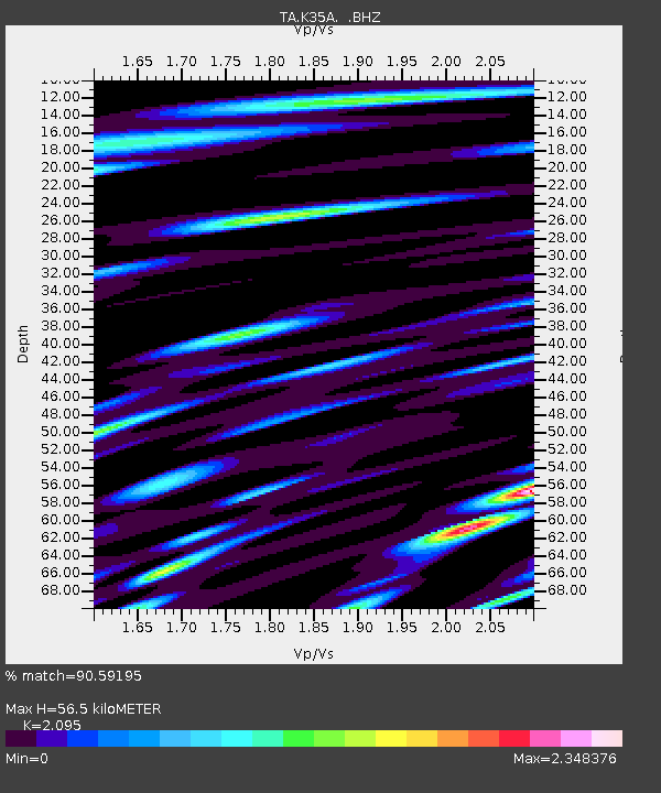
| Estimated Moho Depth: |
56.5 km |
| Estimated Crust Vp/Vs: |
2.10 |
| Assumed Crust Vp: |
6.53 km/s |
| Estimated Crust Vs: |
3.117 km/s |
| Estimated Crust Poisson's Ratio: |
0.35 |
|
| Radial Match: |
90.59195 % |
| Radial Bump: |
400 |
| Transverse Match: |
78.24995 % |
| Transverse Bump: |
400 |
| SOD ConfigId: |
356183 |
| Insert Time: |
2011-10-06 10:39:27.788 +0000 |
| GWidth: |
2.5 |
| Max Bumps: |
400 |
| Tol: |
0.001 |
|
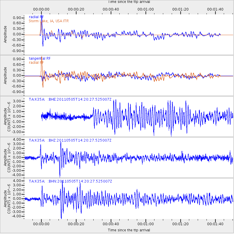
Signal To Noise
| Channel | StoN | STA | LTA |
| TA:K35A: :BHZ:20110505T14:20:27.525007Z | 4.2909756 | 9.3058685E-7 | 2.168707E-7 |
| TA:K35A: :BHN:20110505T14:20:27.525007Z | 3.7608962 | 8.7250226E-7 | 2.3199318E-7 |
| TA:K35A: :BHE:20110505T14:20:27.525007Z | 2.8581128 | 9.953848E-7 | 3.4826647E-7 |
| Arrivals |
| Ps | 10 SECOND |
| PpPs | 25 SECOND |
| PsPs/PpSs | 35 SECOND |


