You are here: Home > Network List > TA - USArray Transportable Network (new EarthScope stations) Stations List
> Station H32A Carlson Farm, Erwin, SD, USA > Earthquake Result Viewer
H32A Carlson Farm, Erwin, SD, USA - Earthquake Result Viewer
| Earthquake location: |
Alaska Peninsula |
| Earthquake latitude/longitude: |
55.1/-160.5 |
| Earthquake time(UTC): |
2011/05/05 (125) 14:13:01 GMT |
| Earthquake Depth: |
39 km |
| Earthquake Magnitude: |
5.9 MB, 5.3 MS, 5.7 MW, 5.7 MW |
| Earthquake Catalog/Contributor: |
WHDF/NEIC |
|
| Network: |
TA USArray Transportable Network (new EarthScope stations) |
| Station: |
H32A Carlson Farm, Erwin, SD, USA |
| Lat/Lon: |
44.50 N/97.44 W |
| Elevation: |
573 m |
|
| Distance: |
40.7 deg |
| Az: |
77.913 deg |
| Baz: |
308.232 deg |
| Ray Param: |
0.07413667 |
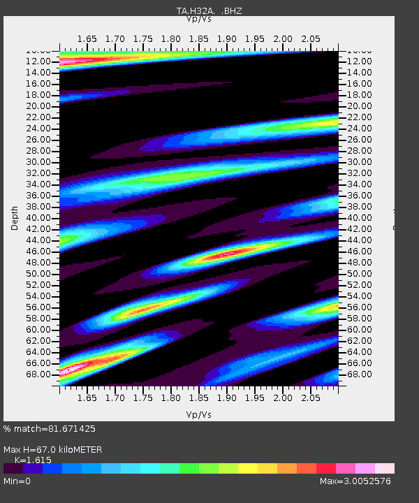
| Estimated Moho Depth: |
67.0 km |
| Estimated Crust Vp/Vs: |
1.62 |
| Assumed Crust Vp: |
6.552 km/s |
| Estimated Crust Vs: |
4.057 km/s |
| Estimated Crust Poisson's Ratio: |
0.19 |
|
| Radial Match: |
81.671425 % |
| Radial Bump: |
400 |
| Transverse Match: |
66.25179 % |
| Transverse Bump: |
400 |
| SOD ConfigId: |
356183 |
| Insert Time: |
2011-10-06 10:42:37.565 +0000 |
| GWidth: |
2.5 |
| Max Bumps: |
400 |
| Tol: |
0.001 |
|

Signal To Noise
| Channel | StoN | STA | LTA |
| TA:H32A: :BHZ:20110505T14:20:08.224989Z | 10.338848 | 1.0246712E-6 | 9.910883E-8 |
| TA:H32A: :BHN:20110505T14:20:08.224989Z | 1.238718 | 4.382764E-7 | 3.5381447E-7 |
| TA:H32A: :BHE:20110505T14:20:08.224989Z | 0.90901333 | 3.1889334E-7 | 3.5081263E-7 |
| Arrivals |
| Ps | 6.8 SECOND |
| PpPs | 25 SECOND |
| PsPs/PpSs | 31 SECOND |


