You are here: Home > Network List > TA - USArray Transportable Network (new EarthScope stations) Stations List
> Station G34A Benson, MN, USA > Earthquake Result Viewer
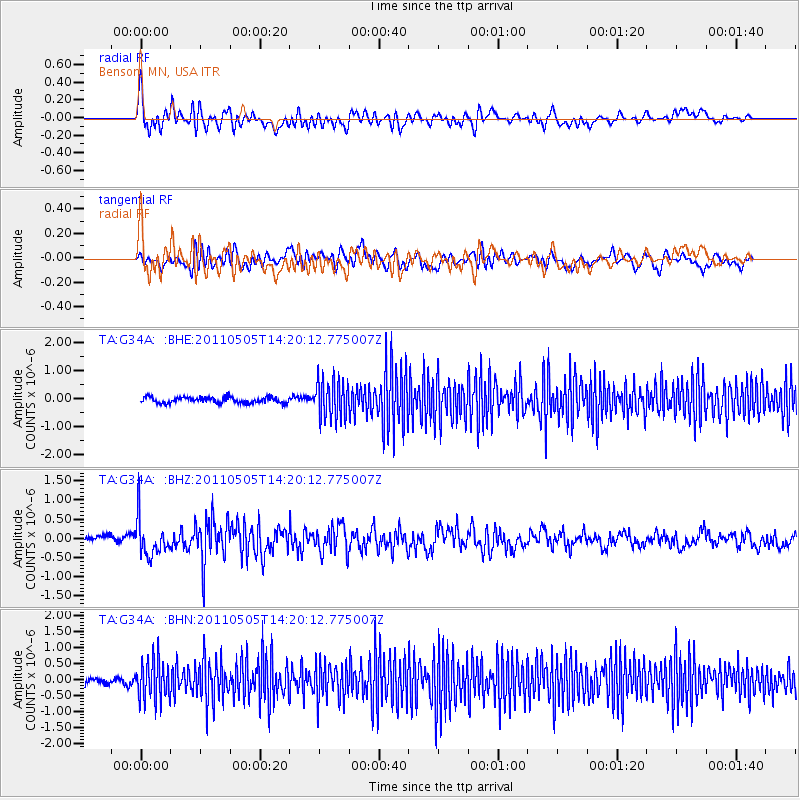
G34A Benson, MN, USA - Earthquake Result Viewer
*The percent match for this event was below the threshold and hence no stack was calculated.
| Earthquake location: |
Alaska Peninsula |
| Earthquake latitude/longitude: |
55.1/-160.5 |
| Earthquake time(UTC): |
2011/05/05 (125) 14:13:01 GMT |
| Earthquake Depth: |
39 km |
| Earthquake Magnitude: |
5.9 MB, 5.3 MS, 5.7 MW, 5.7 MW |
| Earthquake Catalog/Contributor: |
WHDF/NEIC |
|
| Network: |
TA USArray Transportable Network (new EarthScope stations) |
| Station: |
G34A Benson, MN, USA |
| Lat/Lon: |
45.24 N/95.64 W |
| Elevation: |
316 m |
|
| Distance: |
41.3 deg |
| Az: |
75.827 deg |
| Baz: |
307.922 deg |
| Ray Param: |
$rayparam |
*The percent match for this event was below the threshold and hence was not used in the summary stack. |
|
| Radial Match: |
60.77379 % |
| Radial Bump: |
400 |
| Transverse Match: |
53.378937 % |
| Transverse Bump: |
400 |
| SOD ConfigId: |
356183 |
| Insert Time: |
2011-10-06 11:00:10.280 +0000 |
| GWidth: |
2.5 |
| Max Bumps: |
400 |
| Tol: |
0.001 |
|
Signal To Noise
| Channel | StoN | STA | LTA |
| TA:G34A: :BHZ:20110505T14:20:12.775007Z | 4.5833745 | 4.727727E-7 | 1.0314948E-7 |
| TA:G34A: :BHN:20110505T14:20:12.775007Z | 5.2742043 | 6.348723E-7 | 1.203731E-7 |
| TA:G34A: :BHE:20110505T14:20:12.775007Z | 6.505302 | 6.8917103E-7 | 1.0593989E-7 |
| Arrivals |
| Ps | |
| PpPs | |
| PsPs/PpSs | |


