You are here: Home > Network List > TA - USArray Transportable Network (new EarthScope stations) Stations List
> Station K37A Belmond, IA, USA > Earthquake Result Viewer
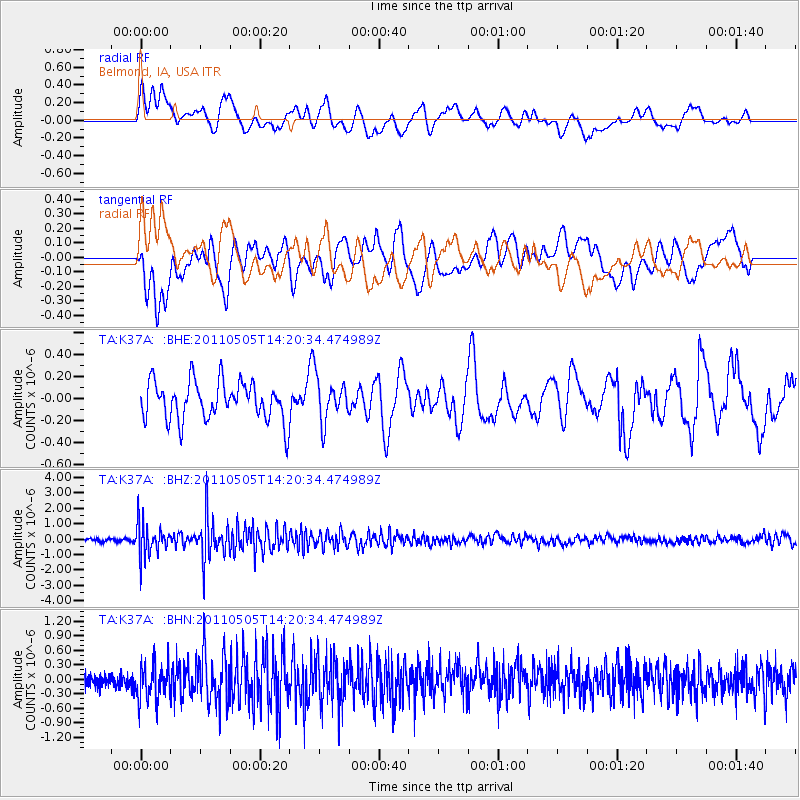
K37A Belmond, IA, USA - Earthquake Result Viewer
*The percent match for this event was below the threshold and hence no stack was calculated.
| Earthquake location: |
Alaska Peninsula |
| Earthquake latitude/longitude: |
55.1/-160.5 |
| Earthquake time(UTC): |
2011/05/05 (125) 14:13:01 GMT |
| Earthquake Depth: |
39 km |
| Earthquake Magnitude: |
5.9 MB, 5.3 MS, 5.7 MW, 5.7 MW |
| Earthquake Catalog/Contributor: |
WHDF/NEIC |
|
| Network: |
TA USArray Transportable Network (new EarthScope stations) |
| Station: |
K37A Belmond, IA, USA |
| Lat/Lon: |
42.77 N/93.64 W |
| Elevation: |
365 m |
|
| Distance: |
44.0 deg |
| Az: |
77.314 deg |
| Baz: |
310.401 deg |
| Ray Param: |
$rayparam |
*The percent match for this event was below the threshold and hence was not used in the summary stack. |
|
| Radial Match: |
67.58118 % |
| Radial Bump: |
400 |
| Transverse Match: |
64.238335 % |
| Transverse Bump: |
400 |
| SOD ConfigId: |
356183 |
| Insert Time: |
2011-10-06 11:09:49.081 +0000 |
| GWidth: |
2.5 |
| Max Bumps: |
400 |
| Tol: |
0.001 |
|
Signal To Noise
| Channel | StoN | STA | LTA |
| TA:K37A: :BHZ:20110505T14:20:34.474989Z | 8.354629 | 1.0685558E-6 | 1.2789985E-7 |
| TA:K37A: :BHN:20110505T14:20:34.474989Z | 1.6817974 | 3.598708E-7 | 2.1397989E-7 |
| TA:K37A: :BHE:20110505T14:20:34.474989Z | 1.1210608 | 1.9688471E-7 | 1.7562357E-7 |
| Arrivals |
| Ps | |
| PpPs | |
| PsPs/PpSs | |


