You are here: Home > Network List > TA - USArray Transportable Network (new EarthScope stations) Stations List
> Station E36A McGregor, MN, USA > Earthquake Result Viewer
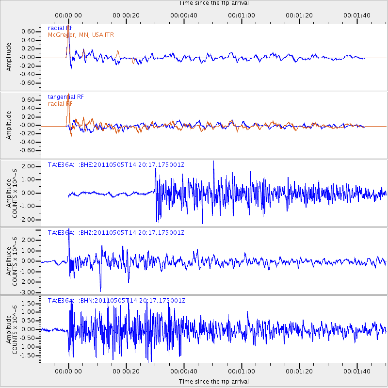
E36A McGregor, MN, USA - Earthquake Result Viewer
| Earthquake location: |
Alaska Peninsula |
| Earthquake latitude/longitude: |
55.1/-160.5 |
| Earthquake time(UTC): |
2011/05/05 (125) 14:13:01 GMT |
| Earthquake Depth: |
39 km |
| Earthquake Magnitude: |
5.9 MB, 5.3 MS, 5.7 MW, 5.7 MW |
| Earthquake Catalog/Contributor: |
WHDF/NEIC |
|
| Network: |
TA USArray Transportable Network (new EarthScope stations) |
| Station: |
E36A McGregor, MN, USA |
| Lat/Lon: |
46.52 N/93.26 W |
| Elevation: |
393 m |
|
| Distance: |
41.8 deg |
| Az: |
72.772 deg |
| Baz: |
307.341 deg |
| Ray Param: |
0.073452175 |
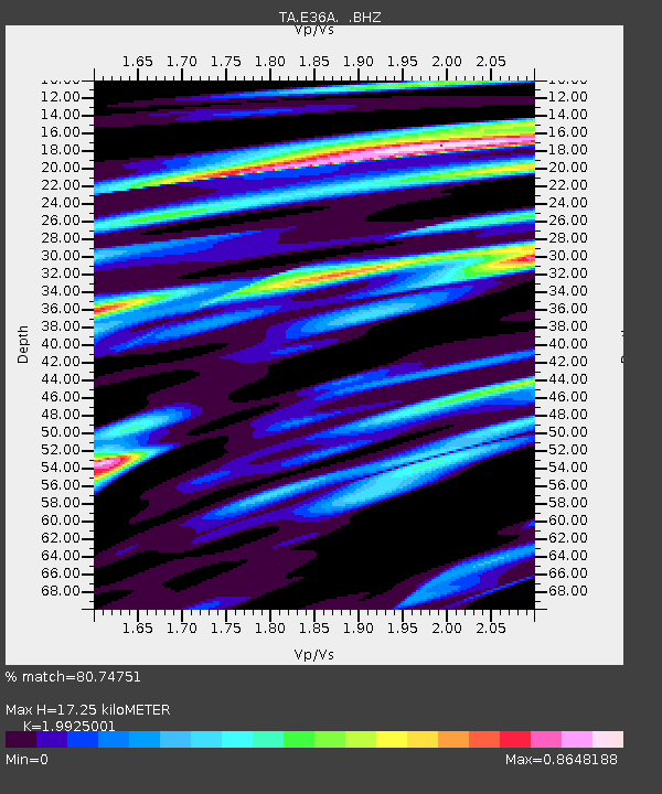
| Estimated Moho Depth: |
17.25 km |
| Estimated Crust Vp/Vs: |
1.99 |
| Assumed Crust Vp: |
6.571 km/s |
| Estimated Crust Vs: |
3.298 km/s |
| Estimated Crust Poisson's Ratio: |
0.33 |
|
| Radial Match: |
80.74751 % |
| Radial Bump: |
400 |
| Transverse Match: |
61.313557 % |
| Transverse Bump: |
400 |
| SOD ConfigId: |
356183 |
| Insert Time: |
2011-10-06 11:11:16.068 +0000 |
| GWidth: |
2.5 |
| Max Bumps: |
400 |
| Tol: |
0.001 |
|
Signal To Noise
| Channel | StoN | STA | LTA |
| TA:E36A: :BHZ:20110505T14:20:17.175001Z | 8.764595 | 8.698077E-7 | 9.9241056E-8 |
| TA:E36A: :BHN:20110505T14:20:17.175001Z | 8.803654 | 7.218373E-7 | 8.199292E-8 |
| TA:E36A: :BHE:20110505T14:20:17.175001Z | 9.542481 | 8.6939065E-7 | 9.1107395E-8 |
| Arrivals |
| Ps | 2.8 SECOND |
| PpPs | 7.4 SECOND |
| PsPs/PpSs | 10 SECOND |


