You are here: Home > Network List > TA - USArray Transportable Network (new EarthScope stations) Stations List
> Station F32A Veblen, SD, USA > Earthquake Result Viewer
F32A Veblen, SD, USA - Earthquake Result Viewer
| Earthquake location: |
Alaska Peninsula |
| Earthquake latitude/longitude: |
55.1/-160.5 |
| Earthquake time(UTC): |
2011/05/05 (125) 14:13:01 GMT |
| Earthquake Depth: |
39 km |
| Earthquake Magnitude: |
5.9 MB, 5.3 MS, 5.7 MW, 5.7 MW |
| Earthquake Catalog/Contributor: |
WHDF/NEIC |
|
| Network: |
TA USArray Transportable Network (new EarthScope stations) |
| Station: |
F32A Veblen, SD, USA |
| Lat/Lon: |
45.87 N/97.13 W |
| Elevation: |
371 m |
|
| Distance: |
40.1 deg |
| Az: |
76.037 deg |
| Baz: |
307.022 deg |
| Ray Param: |
0.07451758 |
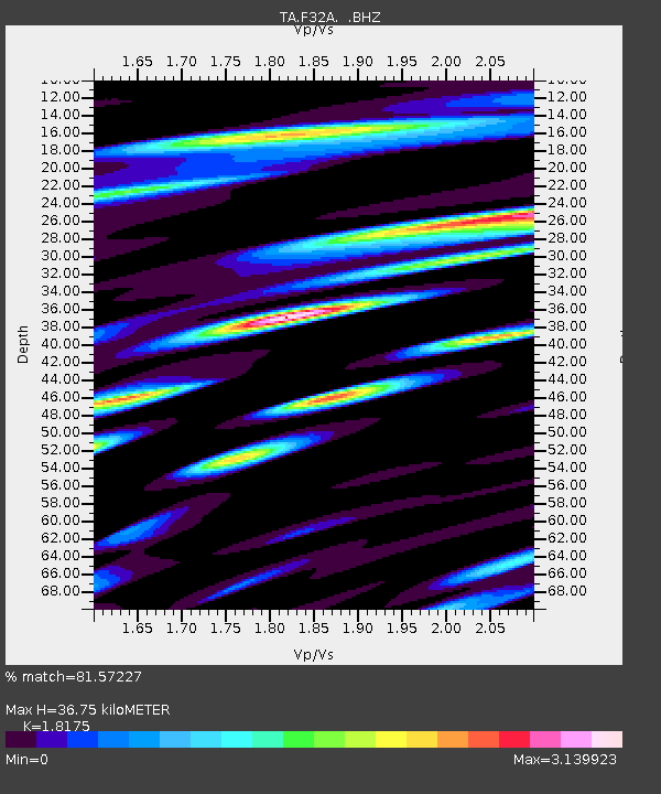
| Estimated Moho Depth: |
36.75 km |
| Estimated Crust Vp/Vs: |
1.82 |
| Assumed Crust Vp: |
6.552 km/s |
| Estimated Crust Vs: |
3.605 km/s |
| Estimated Crust Poisson's Ratio: |
0.28 |
|
| Radial Match: |
81.57227 % |
| Radial Bump: |
400 |
| Transverse Match: |
65.169945 % |
| Transverse Bump: |
400 |
| SOD ConfigId: |
356183 |
| Insert Time: |
2011-10-06 11:13:31.861 +0000 |
| GWidth: |
2.5 |
| Max Bumps: |
400 |
| Tol: |
0.001 |
|
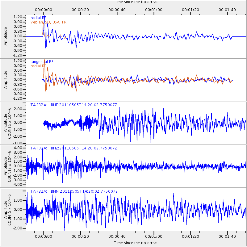
Signal To Noise
| Channel | StoN | STA | LTA |
| TA:F32A: :BHZ:20110505T14:20:02.775007Z | 1.5524927 | 1.0556956E-6 | 6.8000037E-7 |
| TA:F32A: :BHN:20110505T14:20:02.775007Z | 1.3710866 | 6.5977866E-7 | 4.812086E-7 |
| TA:F32A: :BHE:20110505T14:20:02.775007Z | 2.162673 | 8.740668E-7 | 4.041604E-7 |
| Arrivals |
| Ps | 4.9 SECOND |
| PpPs | 15 SECOND |
| PsPs/PpSs | 20 SECOND |


