You are here: Home > Network List > TA - USArray Transportable Network (new EarthScope stations) Stations List
> Station Z47A Carrollton, AL, USA > Earthquake Result Viewer
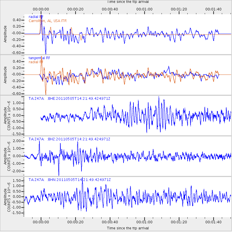
Z47A Carrollton, AL, USA - Earthquake Result Viewer
*The percent match for this event was below the threshold and hence no stack was calculated.
| Earthquake location: |
Alaska Peninsula |
| Earthquake latitude/longitude: |
55.1/-160.5 |
| Earthquake time(UTC): |
2011/05/05 (125) 14:13:01 GMT |
| Earthquake Depth: |
39 km |
| Earthquake Magnitude: |
5.9 MB, 5.3 MS, 5.7 MW, 5.7 MW |
| Earthquake Catalog/Contributor: |
WHDF/NEIC |
|
| Network: |
TA USArray Transportable Network (new EarthScope stations) |
| Station: |
Z47A Carrollton, AL, USA |
| Lat/Lon: |
33.20 N/88.07 W |
| Elevation: |
65 m |
|
| Distance: |
53.8 deg |
| Az: |
82.406 deg |
| Baz: |
317.191 deg |
| Ray Param: |
$rayparam |
*The percent match for this event was below the threshold and hence was not used in the summary stack. |
|
| Radial Match: |
70.49359 % |
| Radial Bump: |
400 |
| Transverse Match: |
60.3589 % |
| Transverse Bump: |
400 |
| SOD ConfigId: |
356183 |
| Insert Time: |
2011-10-06 11:54:19.659 +0000 |
| GWidth: |
2.5 |
| Max Bumps: |
400 |
| Tol: |
0.001 |
|
Signal To Noise
| Channel | StoN | STA | LTA |
| TA:Z47A: :BHZ:20110505T14:21:49.424971Z | 4.341059 | 5.8941686E-7 | 1.357772E-7 |
| TA:Z47A: :BHN:20110505T14:21:49.424971Z | 1.4377623 | 3.3439127E-7 | 2.3257759E-7 |
| TA:Z47A: :BHE:20110505T14:21:49.424971Z | 2.4879677 | 4.0922185E-7 | 1.6448037E-7 |
| Arrivals |
| Ps | |
| PpPs | |
| PsPs/PpSs | |


