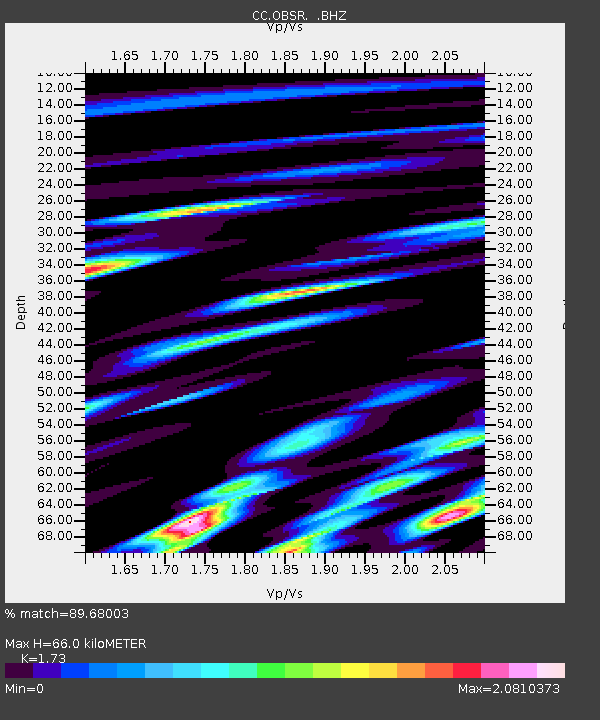
OBSR Observation Rock, Mt. Rainier, WA - Earthquake Result Viewer

Earthquake location: Off East Coast Of Honshu, Japan
Earthquake latitude/longitude: 38.2/144.0
Earthquake time(UTC): 2011/05/05 (125) 14:58:18 GMT
Earthquake Depth: 11 km
Earthquake Magnitude: 6.2 MB, 5.7 MS, 6.1 MW, 6.1 MW
Earthquake Catalog/Contributor: WHDF/NEIC
Network: CC Cascade Chain Volcano Monitoring
Station: OBSR Observation Rock, Mt. Rainier, WA
Lat/Lon: 46.90 N/121.82 W
Elevation: 2382 m
Distance: 65.9 deg
Az: 48.539 deg
Baz: 300.527 deg
Ray Param: 0.05798615
Estimated Moho Depth: 66.0 km
Estimated Crust Vp/Vs: 1.73
Assumed Crust Vp: 6.597 km/s
Estimated Crust Vs: 3.814 km/s
Estimated Crust Poisson's Ratio: 0.25
Radial Match: 89.68003 %
Radial Bump: 400
Transverse Match: 88.01595 %
Transverse Bump: 400
SOD ConfigId: 356183
Insert Time: 2011-10-06 12:47:38.737 +0000
GWidth: 2.5
Max Bumps: 400
Tol: 0.001

Signal To Noise

ChannelStoNSTALTA
CC:OBSR: :BHZ:20110505T15:08:33.039985Z12.0662051.5679375E-61.2994454E-7
CC:OBSR: :BHN:20110505T15:08:33.039985Z3.76758537.377514E-71.9581545E-7
CC:OBSR: :BHE:20110505T15:08:33.039985Z4.6154466.643886E-71.4394895E-7
Arrivals
Ps7.6 SECOND
PpPs26 SECOND
PsPs/PpSs34 SECOND