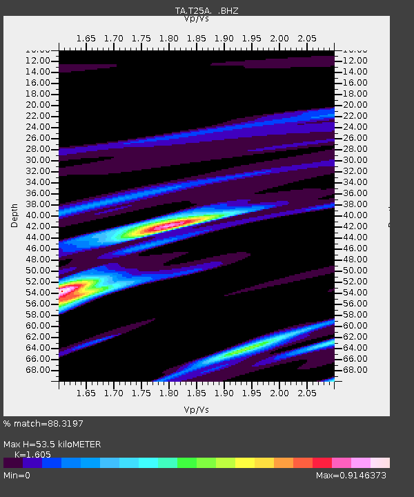
T25A Trinidad, CO, USA - Earthquake Result Viewer
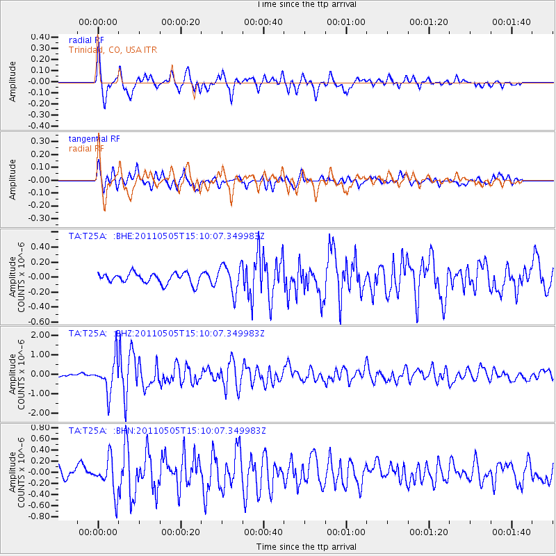
Earthquake location: Off East Coast Of Honshu, Japan
Earthquake latitude/longitude: 38.2/144.0
Earthquake time(UTC): 2011/05/05 (125) 14:58:18 GMT
Earthquake Depth: 11 km
Earthquake Magnitude: 6.2 MB, 5.7 MS, 6.1 MW, 6.1 MW
Earthquake Catalog/Contributor: WHDF/NEIC
Network: TA USArray Transportable Network (new EarthScope stations)
Station: T25A Trinidad, CO, USA
Lat/Lon: 37.14 N/104.41 W
Elevation: 2017 m
Distance: 82.0 deg
Az: 48.63 deg
Baz: 312.252 deg
Ray Param: 0.047164477
Estimated Moho Depth: 53.5 km
Estimated Crust Vp/Vs: 1.61
Assumed Crust Vp: 6.316 km/s
Estimated Crust Vs: 3.935 km/s
Estimated Crust Poisson's Ratio: 0.18
Radial Match: 88.3197 %
Radial Bump: 400
Transverse Match: 68.792786 %
Transverse Bump: 400
SOD ConfigId: 356183
Insert Time: 2011-10-06 13:42:36.934 +0000
GWidth: 2.5
Max Bumps: 400
Tol: 0.001

Signal To Noise

ChannelStoNSTALTA
TA:T25A: :BHZ:20110505T15:10:07.349983Z6.7160358.8119094E-71.3120702E-7
TA:T25A: :BHN:20110505T15:10:07.349983Z2.63084083.2439772E-71.2330571E-7
TA:T25A: :BHE:20110505T15:10:07.349983Z2.73332881.8832834E-76.8900725E-8
Arrivals
Ps5.3 SECOND
PpPs21 SECOND
PsPs/PpSs27 SECOND