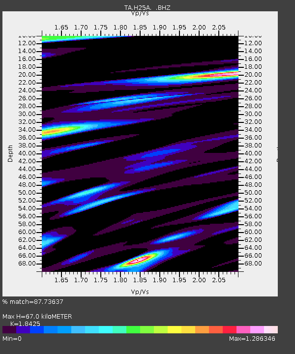
H25A Fruitdale, SD, USA - Earthquake Result Viewer
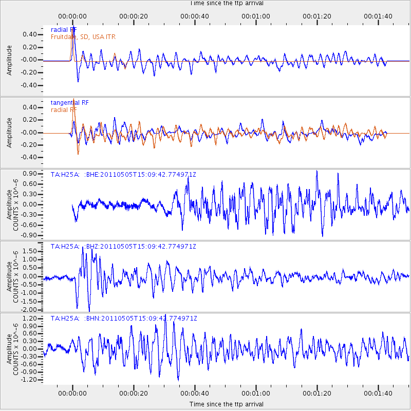
Earthquake location: Off East Coast Of Honshu, Japan
Earthquake latitude/longitude: 38.2/144.0
Earthquake time(UTC): 2011/05/05 (125) 14:58:18 GMT
Earthquake Depth: 11 km
Earthquake Magnitude: 6.2 MB, 5.7 MS, 6.1 MW, 6.1 MW
Earthquake Catalog/Contributor: WHDF/NEIC
Network: TA USArray Transportable Network (new EarthScope stations)
Station: H25A Fruitdale, SD, USA
Lat/Lon: 44.62 N/103.60 W
Elevation: 942 m
Distance: 77.5 deg
Az: 42.566 deg
Baz: 311.703 deg
Ray Param: 0.050285004
Estimated Moho Depth: 67.0 km
Estimated Crust Vp/Vs: 1.84
Assumed Crust Vp: 6.242 km/s
Estimated Crust Vs: 3.388 km/s
Estimated Crust Poisson's Ratio: 0.29
Radial Match: 87.73637 %
Radial Bump: 400
Transverse Match: 87.11187 %
Transverse Bump: 400
SOD ConfigId: 356183
Insert Time: 2011-10-06 13:56:19.532 +0000
GWidth: 2.5
Max Bumps: 400
Tol: 0.001

Signal To Noise

ChannelStoNSTALTA
TA:H25A: :BHZ:20110505T15:09:42.774971Z9.9209738.385527E-78.4523236E-8
TA:H25A: :BHN:20110505T15:09:42.774971Z2.24554543.584125E-71.5961045E-7
TA:H25A: :BHE:20110505T15:09:42.774971Z1.88444912.1565376E-71.1443863E-7
Arrivals
Ps9.3 SECOND
PpPs30 SECOND
PsPs/PpSs39 SECOND