You are here: Home > Network List > TA - USArray Transportable Network (new EarthScope stations) Stations List
> Station B28A Dugan Ranch, Towner, ND, USA > Earthquake Result Viewer
B28A Dugan Ranch, Towner, ND, USA - Earthquake Result Viewer
| Earthquake location: |
Off East Coast Of Honshu, Japan |
| Earthquake latitude/longitude: |
38.2/144.0 |
| Earthquake time(UTC): |
2011/05/05 (125) 14:58:18 GMT |
| Earthquake Depth: |
11 km |
| Earthquake Magnitude: |
6.2 MB, 5.7 MS, 6.1 MW, 6.1 MW |
| Earthquake Catalog/Contributor: |
WHDF/NEIC |
|
| Network: |
TA USArray Transportable Network (new EarthScope stations) |
| Station: |
B28A Dugan Ranch, Towner, ND, USA |
| Lat/Lon: |
48.45 N/100.36 W |
| Elevation: |
451 m |
|
| Distance: |
76.6 deg |
| Az: |
38.118 deg |
| Baz: |
313.047 deg |
| Ray Param: |
0.050909754 |
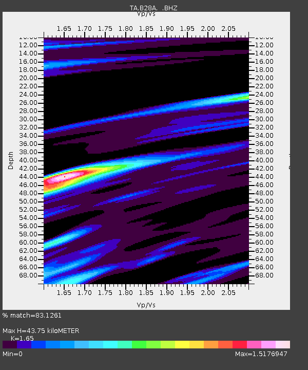
| Estimated Moho Depth: |
43.75 km |
| Estimated Crust Vp/Vs: |
1.65 |
| Assumed Crust Vp: |
6.438 km/s |
| Estimated Crust Vs: |
3.902 km/s |
| Estimated Crust Poisson's Ratio: |
0.21 |
|
| Radial Match: |
83.1261 % |
| Radial Bump: |
400 |
| Transverse Match: |
68.23002 % |
| Transverse Bump: |
400 |
| SOD ConfigId: |
356183 |
| Insert Time: |
2011-10-06 14:06:01.138 +0000 |
| GWidth: |
2.5 |
| Max Bumps: |
400 |
| Tol: |
0.001 |
|

Signal To Noise
| Channel | StoN | STA | LTA |
| TA:B28A: :BHZ:20110505T15:09:37.57502Z | 8.851697 | 1.2765871E-6 | 1.4421948E-7 |
| TA:B28A: :BHN:20110505T15:09:37.57502Z | 3.1953113 | 5.1126426E-7 | 1.6000453E-7 |
| TA:B28A: :BHE:20110505T15:09:37.57502Z | 1.6408195 | 3.7858243E-7 | 2.3072764E-7 |
| Arrivals |
| Ps | 4.6 SECOND |
| PpPs | 17 SECOND |
| PsPs/PpSs | 22 SECOND |


