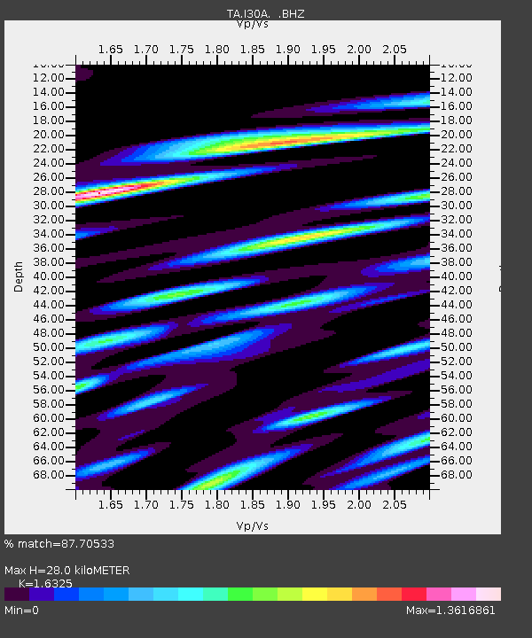
I30A Oacoma, SD, USA - Earthquake Result Viewer
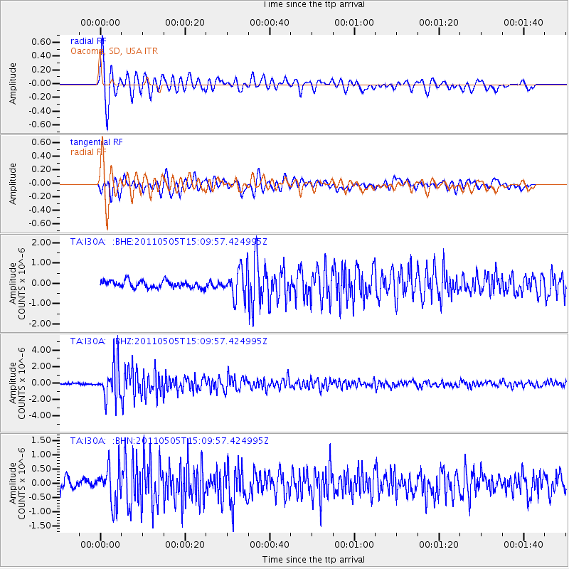
Earthquake location: Off East Coast Of Honshu, Japan
Earthquake latitude/longitude: 38.2/144.0
Earthquake time(UTC): 2011/05/05 (125) 14:58:18 GMT
Earthquake Depth: 11 km
Earthquake Magnitude: 6.2 MB, 5.7 MS, 6.1 MW, 6.1 MW
Earthquake Catalog/Contributor: WHDF/NEIC
Network: TA USArray Transportable Network (new EarthScope stations)
Station: I30A Oacoma, SD, USA
Lat/Lon: 43.91 N/99.43 W
Elevation: 549 m
Distance: 80.2 deg
Az: 41.009 deg
Baz: 314.304 deg
Ray Param: 0.048461717
Estimated Moho Depth: 28.0 km
Estimated Crust Vp/Vs: 1.63
Assumed Crust Vp: 6.53 km/s
Estimated Crust Vs: 4.0 km/s
Estimated Crust Poisson's Ratio: 0.20
Radial Match: 87.70533 %
Radial Bump: 400
Transverse Match: 81.761116 %
Transverse Bump: 400
SOD ConfigId: 356183
Insert Time: 2011-10-06 14:14:51.395 +0000
GWidth: 2.5
Max Bumps: 400
Tol: 0.001

Signal To Noise

ChannelStoNSTALTA
TA:I30A: :BHZ:20110505T15:09:57.424995Z22.042662.0801197E-69.436791E-8
TA:I30A: :BHN:20110505T15:09:57.424995Z3.49843366.5047976E-71.8593458E-7
TA:I30A: :BHE:20110505T15:09:57.424995Z4.28023347.4645425E-71.7439568E-7
Arrivals
Ps2.8 SECOND
PpPs11 SECOND
PsPs/PpSs14 SECOND