You are here: Home > Network List > TA - USArray Transportable Network (new EarthScope stations) Stations List
> Station S34A Willow Spring Farm, Andover, KS, USA > Earthquake Result Viewer
S34A Willow Spring Farm, Andover, KS, USA - Earthquake Result Viewer
| Earthquake location: |
Off East Coast Of Honshu, Japan |
| Earthquake latitude/longitude: |
38.2/144.0 |
| Earthquake time(UTC): |
2011/05/05 (125) 14:58:18 GMT |
| Earthquake Depth: |
11 km |
| Earthquake Magnitude: |
6.2 MB, 5.7 MS, 6.1 MW, 6.1 MW |
| Earthquake Catalog/Contributor: |
WHDF/NEIC |
|
| Network: |
TA USArray Transportable Network (new EarthScope stations) |
| Station: |
S34A Willow Spring Farm, Andover, KS, USA |
| Lat/Lon: |
37.70 N/97.11 W |
| Elevation: |
373 m |
|
| Distance: |
85.8 deg |
| Az: |
44.152 deg |
| Baz: |
316.198 deg |
| Ray Param: |
0.04449507 |
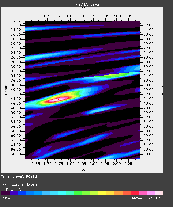
| Estimated Moho Depth: |
44.0 km |
| Estimated Crust Vp/Vs: |
1.75 |
| Assumed Crust Vp: |
6.483 km/s |
| Estimated Crust Vs: |
3.715 km/s |
| Estimated Crust Poisson's Ratio: |
0.26 |
|
| Radial Match: |
85.60312 % |
| Radial Bump: |
400 |
| Transverse Match: |
72.99098 % |
| Transverse Bump: |
400 |
| SOD ConfigId: |
356183 |
| Insert Time: |
2011-10-06 14:41:02.913 +0000 |
| GWidth: |
2.5 |
| Max Bumps: |
400 |
| Tol: |
0.001 |
|

Signal To Noise
| Channel | StoN | STA | LTA |
| TA:S34A: :BHZ:20110505T15:10:26.549995Z | 9.485009 | 1.0368734E-6 | 1.0931706E-7 |
| TA:S34A: :BHN:20110505T15:10:26.549995Z | 1.2895972 | 1.4548884E-7 | 1.12817276E-7 |
| TA:S34A: :BHE:20110505T15:10:26.549995Z | 3.2036963 | 2.579571E-7 | 8.051859E-8 |
| Arrivals |
| Ps | 5.2 SECOND |
| PpPs | 18 SECOND |
| PsPs/PpSs | 23 SECOND |


