You are here: Home > Network List > TA - USArray Transportable Network (new EarthScope stations) Stations List
> Station T35A Sooner Cattle Company, Foraker, OK, USA > Earthquake Result Viewer
T35A Sooner Cattle Company, Foraker, OK, USA - Earthquake Result Viewer
| Earthquake location: |
Off East Coast Of Honshu, Japan |
| Earthquake latitude/longitude: |
38.2/144.0 |
| Earthquake time(UTC): |
2011/05/05 (125) 14:58:18 GMT |
| Earthquake Depth: |
11 km |
| Earthquake Magnitude: |
6.2 MB, 5.7 MS, 6.1 MW, 6.1 MW |
| Earthquake Catalog/Contributor: |
WHDF/NEIC |
|
| Network: |
TA USArray Transportable Network (new EarthScope stations) |
| Station: |
T35A Sooner Cattle Company, Foraker, OK, USA |
| Lat/Lon: |
36.92 N/96.51 W |
| Elevation: |
401 m |
|
| Distance: |
86.7 deg |
| Az: |
44.347 deg |
| Baz: |
316.572 deg |
| Ray Param: |
0.04385377 |
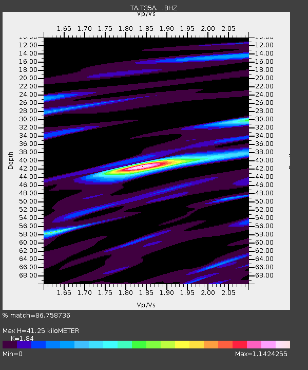
| Estimated Moho Depth: |
41.25 km |
| Estimated Crust Vp/Vs: |
1.84 |
| Assumed Crust Vp: |
6.483 km/s |
| Estimated Crust Vs: |
3.523 km/s |
| Estimated Crust Poisson's Ratio: |
0.29 |
|
| Radial Match: |
86.758736 % |
| Radial Bump: |
400 |
| Transverse Match: |
73.583984 % |
| Transverse Bump: |
400 |
| SOD ConfigId: |
356183 |
| Insert Time: |
2011-10-06 14:49:27.316 +0000 |
| GWidth: |
2.5 |
| Max Bumps: |
400 |
| Tol: |
0.001 |
|
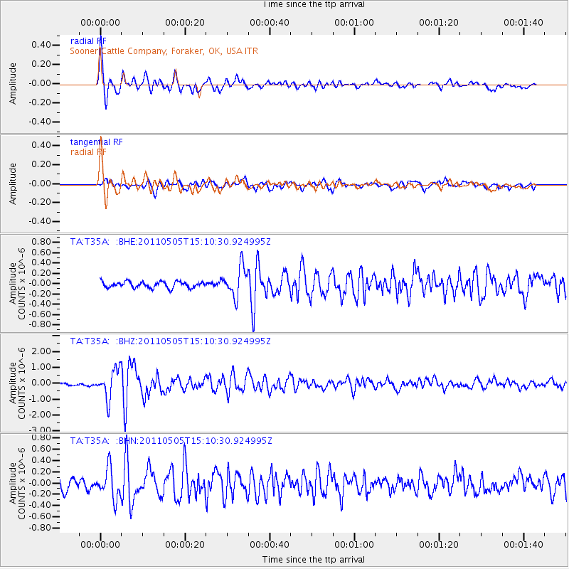
Signal To Noise
| Channel | StoN | STA | LTA |
| TA:T35A: :BHZ:20110505T15:10:30.924995Z | 9.365153 | 9.4107634E-7 | 1.00487014E-7 |
| TA:T35A: :BHN:20110505T15:10:30.924995Z | 2.4437313 | 2.767638E-7 | 1.1325459E-7 |
| TA:T35A: :BHE:20110505T15:10:30.924995Z | 5.016664 | 2.9834416E-7 | 5.947063E-8 |
| Arrivals |
| Ps | 5.5 SECOND |
| PpPs | 18 SECOND |
| PsPs/PpSs | 23 SECOND |


