You are here: Home > Network List > TA - USArray Transportable Network (new EarthScope stations) Stations List
> Station M34A Aspy Farms, Fremont, NE, USA > Earthquake Result Viewer
M34A Aspy Farms, Fremont, NE, USA - Earthquake Result Viewer
| Earthquake location: |
Off East Coast Of Honshu, Japan |
| Earthquake latitude/longitude: |
38.2/144.0 |
| Earthquake time(UTC): |
2011/05/05 (125) 14:58:18 GMT |
| Earthquake Depth: |
11 km |
| Earthquake Magnitude: |
6.2 MB, 5.7 MS, 6.1 MW, 6.1 MW |
| Earthquake Catalog/Contributor: |
WHDF/NEIC |
|
| Network: |
TA USArray Transportable Network (new EarthScope stations) |
| Station: |
M34A Aspy Farms, Fremont, NE, USA |
| Lat/Lon: |
41.50 N/96.58 W |
| Elevation: |
415 m |
|
| Distance: |
83.4 deg |
| Az: |
41.218 deg |
| Baz: |
316.256 deg |
| Ray Param: |
0.0462484 |
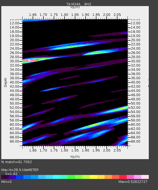
| Estimated Moho Depth: |
29.5 km |
| Estimated Crust Vp/Vs: |
1.62 |
| Assumed Crust Vp: |
6.498 km/s |
| Estimated Crust Vs: |
4.011 km/s |
| Estimated Crust Poisson's Ratio: |
0.19 |
|
| Radial Match: |
81.7052 % |
| Radial Bump: |
400 |
| Transverse Match: |
70.68134 % |
| Transverse Bump: |
400 |
| SOD ConfigId: |
356183 |
| Insert Time: |
2011-10-06 14:54:27.070 +0000 |
| GWidth: |
2.5 |
| Max Bumps: |
400 |
| Tol: |
0.001 |
|

Signal To Noise
| Channel | StoN | STA | LTA |
| TA:M34A: :BHZ:20110505T15:10:14.149971Z | 3.829521 | 1.2050211E-6 | 3.146663E-7 |
| TA:M34A: :BHN:20110505T15:10:14.149971Z | 2.2416964 | 9.972674E-7 | 4.4487177E-7 |
| TA:M34A: :BHE:20110505T15:10:14.149971Z | 1.2700183 | 6.426158E-7 | 5.059894E-7 |
| Arrivals |
| Ps | 2.9 SECOND |
| PpPs | 12 SECOND |
| PsPs/PpSs | 14 SECOND |


