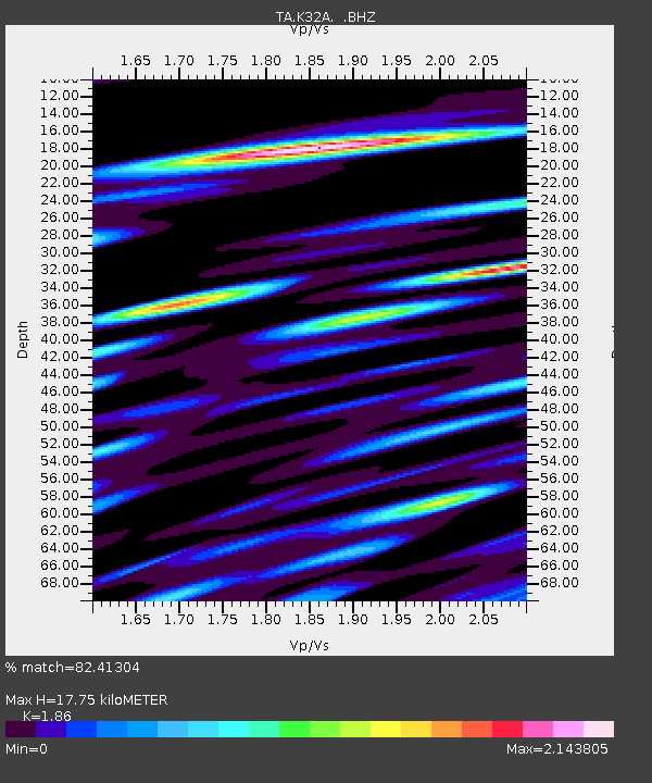
K32A Verdigre, NE, USA - Earthquake Result Viewer
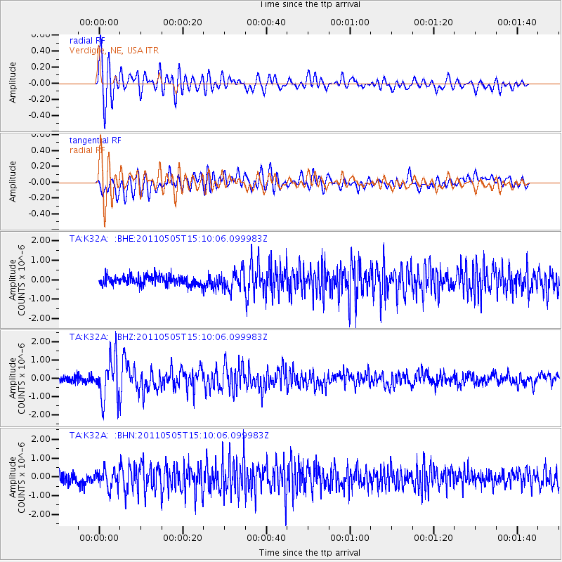
Earthquake location: Off East Coast Of Honshu, Japan
Earthquake latitude/longitude: 38.2/144.0
Earthquake time(UTC): 2011/05/05 (125) 14:58:18 GMT
Earthquake Depth: 11 km
Earthquake Magnitude: 6.2 MB, 5.7 MS, 6.1 MW, 6.1 MW
Earthquake Catalog/Contributor: WHDF/NEIC
Network: TA USArray Transportable Network (new EarthScope stations)
Station: K32A Verdigre, NE, USA
Lat/Lon: 42.66 N/97.97 W
Elevation: 512 m
Distance: 81.8 deg
Az: 41.152 deg
Baz: 315.32 deg
Ray Param: 0.047329493
Estimated Moho Depth: 17.75 km
Estimated Crust Vp/Vs: 1.86
Assumed Crust Vp: 6.498 km/s
Estimated Crust Vs: 3.493 km/s
Estimated Crust Poisson's Ratio: 0.30
Radial Match: 82.41304 %
Radial Bump: 400
Transverse Match: 75.25727 %
Transverse Bump: 400
SOD ConfigId: 356183
Insert Time: 2011-10-06 15:00:58.770 +0000
GWidth: 2.5
Max Bumps: 400
Tol: 0.001

Signal To Noise

ChannelStoNSTALTA
TA:K32A: :BHZ:20110505T15:10:06.099983Z8.9700691.1675402E-61.3015956E-7
TA:K32A: :BHN:20110505T15:10:06.099983Z2.05129654.8687065E-72.3734776E-7
TA:K32A: :BHE:20110505T15:10:06.099983Z2.06149654.814956E-72.3356604E-7
Arrivals
Ps2.4 SECOND
PpPs7.6 SECOND
PsPs/PpSs10 SECOND